
PLA Western Theatre Command (WTC): Comprehensive Analysis of China’s Largest Military Command
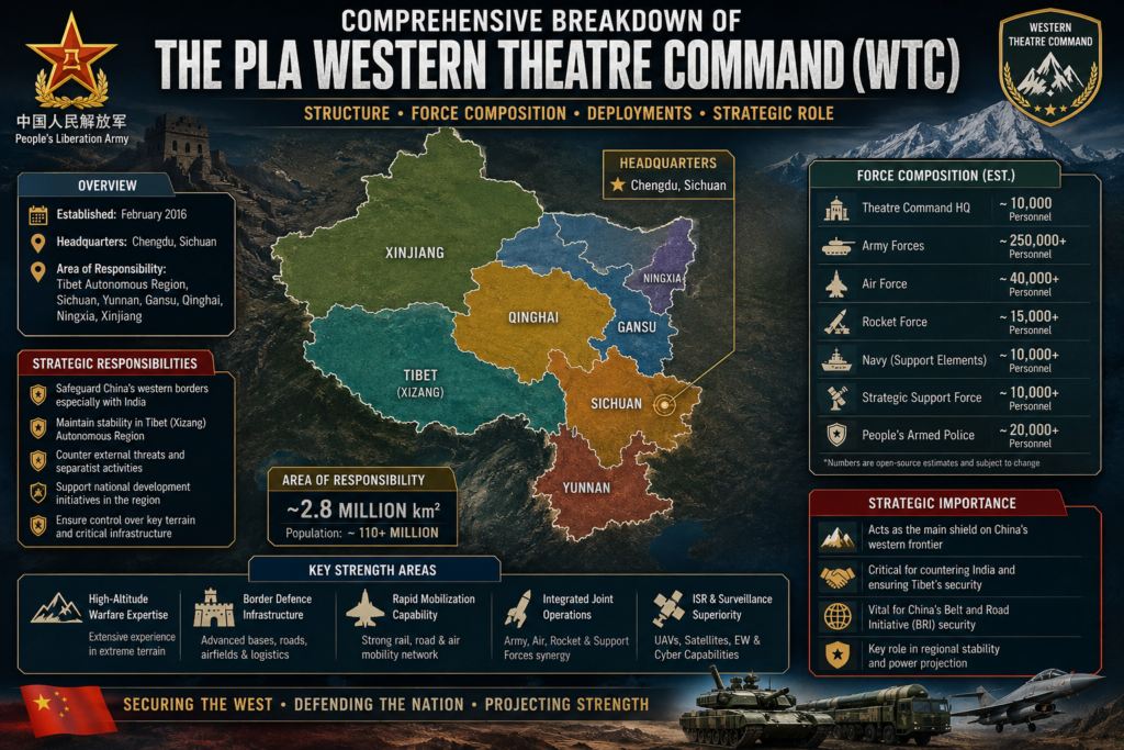
Comprehensive Breakdown of the PLA Western Theater Command
The Western Theater Command (WTC) is one of the five theater commands of the People’s Liberation Army, established on February 1, 2016, as part of China’s sweeping military reforms. It is the largest of the five theater commands and the only one without a coastline — covering vast interior and border regions of strategic importance.
Overview
The Western Theater Command plays a pivotal role in China’s military structure, overseeing operations across some of the country’s most geographically diverse and strategically sensitive territories. From the high-altitude plateaus of Tibet and Qinghai to the vast deserts of Xinjiang and the fertile basins of Sichuan, the WTC commands forces across a region that borders multiple nations, including India, Pakistan, Afghanistan, and Central Asian states.
Jurisdiction
The Western Theater Command leads and commands the armed forces stationed across seven provincial-level administrative regions. These regions span a combined area of more than 5 million square kilometers, encompassing diverse terrain ranging from the Tibetan Plateau to the Taklamakan Desert.
Headquarters
The command structure of the Western Theater Command is distributed across two key locations, reflecting the vast geographic scope of its responsibilities and the need for coordinated leadership across different operational domains.
Commanders
The Western Theater Command has been led by a succession of senior military officers since its establishment. As of mid-2026, the command is under new leadership, reflecting the PLA’s ongoing personnel rotations and modernization efforts.
Strategic Responsibilities
The WTC’s core mission is to “respond to this strategic direction’s security threats, maintain peace, deter war, and win wars.” Its strategic focus is explicitly directed towards South Asia and Central Asia.
- Its primary responsibilities include securing China’s borders with India, Pakistan, Mongolia, Kazakhstan, Kyrgyzstan, and Tajikistan, as well as a small salient bordering Russia.
- It also plays a key role in counterterrorism missions and internal security within the Xinjiang and Tibet Autonomous Regions, where the CCP perceives a high threat of separatism
India-Focused Deployment: Covering the Entire China-India Border
The Western Theater Command is the core PLA force responsible for the defense of the China-India border. Its jurisdiction covers almost the entire 3,488 km-long Line of Actual Control (LAC) with India.
- Western Sector: It covers the area from the northern tip of the Siachen Glacier region in the west.
- Eastern Sector: It extends eastward to cover the entire China-India border, including the tri-junction area where China, India, and Myanmar meet
PLA Western Theater Command: Forward Aviation Bases and Strategic Airlift Hubs Along the LAC
| Official Name | Chinese Name (Simplified & Pinyin) | Military Region / Theater Command / Location / Elevation / Strategic Importance / Operational Status |
|---|---|---|
| Lhasa Gonggar Airport / TMD HQ | 拉萨贡嘎机场 (Lāsà Gònggā Jīchǎng) | Military Region: Tibet Military District (TMD) Theater Command: Western Theater Command (WTC) Location: TAR / Lhasa / Gonggar County Elevation: 3,570 m (11,712 ft) Strategic Importance: Central command, control, and strategic airlift hub of the TMD. Hosts the TMD Headquarters and massive underground logistics nodes. Status: Fully operational; active dual-use (civil-military). |
| Shigatse Peace Airport | 日喀则和平机场 (Rìkāzé Hépíng Jīchǎng) | Military Region: Tibet Military District (TMD) Theater Command: Western Theater Command (WTC) Location: TAR / Shigatse / Sangzhuzi District Elevation: ~3,750 m (12,300 ft) Strategic Importance: Primary PLAAF strike and stealth fighter hub in the central sector. Features 36+ Hardened Aircraft Shelters (HAS). Status: Fully operational; active dual-use; hosts J-20 stealth fighters. |
| Nyingchi Mainling Airport | 林芝米林机场 (Línzhī Mǐlín Jīchǎng) | Military Region: Tibet Military District (TMD) Theater Command: Western Theater Command (WTC) Location: TAR / Nyingchi / Mainling City Elevation: 2,949 m (9,675 ft) Strategic Importance: Critical forward airbase for the Eastern Sector (facing Arunachal Pradesh). Lowest elevation of major bases, allowing higher aircraft payloads. Status: Fully operational; active dual-use. |
| Ngari Gunsa Airport | 阿里昆莎机场 (Āl Kūnshā Jīchǎng) | Military Region: Tibet Military District (TMD) Theater Command: Western Theater Command (WTC) Location: TAR / Ngari Prefecture / Shiquanhe Elevation: 4,411 m (14,472 ft) Strategic Importance: Highest airport in the world; primary hub for the Western Sector (Aksai Chin / Ladakh). Hosts China’s first high-altitude UAV testing base. Status: Fully operational; active dual-use. |
| Chamdo Bangda Airport | 昌都邦达机场 (Chāngdū Bāngdá Jīchǎng) | Military Region: Tibet Military District (TMD) Theater Command: Western Theater Command (WTC) Location: TAR / Chamdo / Bangda Elevation: 4,334 m (14,219 ft) Strategic Importance: Strategic airlift and eastern reserve hub connecting Tibet to Sichuan and interior China. Features one of the world’s longest runways (5,500m). Status: Fully operational; active dual-use. |
| Lhunze Airbase | 隆子机场 (Lóngzǐ Jīchǎng) | Military Region: Tibet Military District (TMD) Theater Command: Western Theater Command (WTC) Location: TAR / Shannan (Lhoka) / Lhunze County Elevation: ~3,900 m (12,800 ft) Strategic Importance: Newly expanded, highly aggressive forward strike base facing Sikkim and Arunachal Pradesh. Recently completed 36 new HAS. Status: Fully operational; heavily expanded military use. |
| Tingri Airbase | 定日机场 (Dìngrì Jīchǎng) | Military Region: Tibet Military District (TMD) Theater Command: Western Theater Command (WTC) Location: TAR / Shigatse / Tingri County Elevation: ~4,300 m (14,100 ft) Strategic Importance: Central/high-altitude forward base near the Nepal border and Mount Everest. Lengthened runways to counter reduced lift in thin air. Status: Fully operational; military/civil dual-use. |
| Burang (Purang) Airbase | 普兰机场 (Pǔlán Jīchǎng) | Military Region: Tibet Military District (TMD) Theater Command: Western Theater Command (WTC) Location: TAR / Ngari Prefecture / Burang County Elevation: ~4,255 m (13,960 ft) Strategic Importance: Central-western sector forward base facing the Lipulekh pass and Uttarakhand sector. Supports rapid response in the western Himalayas. Status: Fully operational; recently expanded for military use. |
PLA Tibet Military District Airbases: Precise Geographic Coordinates & Strategic Distance Analysis
| Official Name / Chinese Designation | Geographic Coordinates & Grid References | Location Context & Strategic Distances |
|---|---|---|
| Lhasa Gonggar Airport / TMD HQ 拉萨贡嘎机场 (Lāsà Gònggā Jīchǎng) | Latitude: 29.2978° N Longitude: 90.9119° E MGRS/UTM: UTM Zone 45R Google Maps: 29.2978, 90.9119 | Nearby Towns/Villages: Gonggar, Lhasa Dist. from LAC: 150-200 km Dist. from Indian Border: 160-220 km Dist. to Nearest Indian Post: >150 km Satellite Imagery: CSIS, Maxar, Google Earth |
| Shigatse Peace Airport 日喀则和平机场 (Rìkāzé Hépíng Jīchǎng) | Latitude: 29.3519° N Longitude: 88.6178° E MGRS/UTM: UTM Zone 44R Google Maps: 29.3519, 88.6178 | Nearby Towns/Villages: Shigatse (Xigaze) Dist. from LAC: 130-150 km Dist. from Indian Border: 140-170 km Dist. to Nearest Indian Post: >130 km Satellite Imagery: ASPI, CSIS, Planet Labs |
| Nyingchi Mainling Airport 林芝米林机场 (Línzhī Mǐlín Jīchǎng) | Latitude: 29.3061° N Longitude: 94.3350° E MGRS/UTM: UTM Zone 46R Google Maps: 29.3061, 94.3350 | Nearby Towns/Villages: Nyingchi, Mainling Dist. from LAC: 40-60 km Dist. from Indian Border: 50-80 km Dist. to Nearest Indian Post: 50-80 km Satellite Imagery: Maxar, Google Earth |
| Ngari Gunsa Airport 阿里昆莎机场 (Ālǐ Kūnshā Jīchǎng) | Latitude: 32.1000° N Longitude: 80.0500° E MGRS/UTM: UTM Zone 44R Google Maps: 32.1000, 80.0500 | Nearby Towns/Villages: Shiquanhe (Ali) Dist. from LAC: 50-80 km Dist. from Indian Border: 60-100 km Dist. to Nearest Indian Post: 60-100 km Satellite Imagery: Maxar, Planet Labs |
| Lhunze Airbase 隆子机场 (Lóngzǐ Jīchǎng) | Latitude: 28.4200° N Longitude: 92.4800° E MGRS/UTM: UTM Zone 46R Google Maps: 28.4200, 92.4800 | Nearby Towns/Villages: Lhunze (Longzi) Dist. from LAC: 20-40 km Dist. from Indian Border: 30-50 km Dist. to Nearest Indian Post: 30-50 km Satellite Imagery: CSIS, ASPI |
| Tingri Airbase 定日机场 (Dìngrì Jīchǎng) | Latitude: 28.6700° N Longitude: 87.1300° E MGRS/UTM: UTM Zone 44R Google Maps: 28.6700, 87.1300 | Nearby Towns/Villages: Tingri, Shegar Dist. from LAC: 40-60 km Dist. from Indian Border: 50-70 km Dist. to Nearest Indian Post: >50 km Satellite Imagery: Google Earth, Planet Labs |
| Chamdo Bangda Airport 昌都邦达机场 (Chāngdū Bāngdá Jīchǎng) | Latitude: 30.5536° N Longitude: 97.1083° E MGRS/UTM: UTM Zone 47R Google Maps: 30.5536, 97.1083 | Nearby Towns/Villages: Chamdo, Bangda Dist. from LAC: 150-200 km Dist. from Indian Border: 180-250 km Dist. to Nearest Indian Post: >150 km Satellite Imagery: Google Earth |
| Burang (Purang) Airbase 普兰机场 (Pǔlán Jīchǎng) | Latitude: 30.2800° N Longitude: 81.2200° E MGRS/UTM: UTM Zone 44R Google Maps: 30.2800, 81.2200 | Nearby Towns/Villages: Burang, Taklakot Dist. from LAC: 30-50 km Dist. from Indian Border: 40-70 km Dist. to Nearest Indian Post: 40-70 km Satellite Imagery: Maxar, Planet Labs |
PLA Tibet Military District (TMD): Administrative Hierarchy and Chain of Command
| Echelon Level | Organization / Unit Designation | Military Unit Number (MUN) / Public Name | Commanding Headquarters | Role & Subordinate Units |
|---|---|---|---|---|
| Supreme Command (PLA) | Central Military Commission (CMC) | N/A | Beijing, China | Supreme military authority. The TMD reports directly to the CMC for strategic and administrative matters due to Tibet’s political sensitivity. |
| Theater Command | Western Theater Command (WTC) | N/A | Chengdu, Sichuan | Joint operations command. The TMD falls under the WTC for operational border defense, joint logistics, and air/rocket force coordination. |
| Group Army / Corps Equivalent | Tibet Military District (TMD) | Unit 77600 (Reported) • 西藏军区 (Xīzàng Jūnqū) | Lhasa, Tibet Autonomous Region | Sub-theater grade provincial command. Commands all Ground Force (PLAGF) units in the TAR. Directly controls combat brigades and regional sub-districts. |
| Division Equivalent | Military Sub-Districts (Jun Fenqu) | Named by Prefecture (e.g., Shigatse Sub-District, Nyingchi Sub-District) | Prefectural Capitals (e.g., Shigatse, Nyingchi, Ngari) | Regional garrison commands. Responsible for local defense, recruitment, civil-military relations, and commanding border defense regiments in their sector. |
| Brigade | Combined Arms Brigades (CAB) & Specialized Brigades | 52nd Mountain CAB, 53rd Mountain CAB, 54th Heavy CAB, 85th Special Operations Brigade | Various Garrisons (e.g., Nyingchi, Lhasa) | Primary tactical maneuver and firepower elements. Organized into battalions and companies. Equipped with armor, artillery, and air defense. |
| Regiment | Border Defense Regiments (BDR) | 351st to 358th Border Defense Regiments (Publicly reported) | Border Towns / Forward Logistics Hubs (e.g., Zayu, Medog, Yadong) | Light infantry formations holding specific sectors of the Line of Actual Control (LAC). Commands border defense battalions. |
| Battalion | Border Defense Battalions (BDB) | Classified / Sequential Numbering | Forward Operating Bases / “Xiaokang” Border Villages | Commands 3 to 5 companies. Responsible for a specific valley or mountain sector. Conducts daily patrols and maintains forward outposts. |
| Company | Border Defense Companies | Classified / Sequential Numbering | Fortified Camps situated a few kilometers behind the LAC | Commands 3 to 4 platoons. Manages the immediate tactical edge, integrating civilian “mass defense” militias and operating local surveillance. |
| Post (Tactical Edge) | Border Defense Posts (Shaoqia) | Numbered by elevation or location (e.g., Post 4300, Finger 4 Post) | Directly on the Line of Actual Control (LAC) or dominating heights | Manned by a single platoon or squad (10-40 soldiers). Conducts visual/drone surveillance and engages in face-to-face standoffs with opposing forces. |
Key Structural Notes for the TMD:
- Direct CMC Reporting: Unlike standard provincial military districts, the TMD Commander holds the rank of Lieutenant General and has a direct reporting line to the Central Military Commission, bypassing standard Western Theater Command bureaucracy for administrative and strategic issues.
- Brigade-Centric Combat: The TMD does not use Divisions or Corps for its combat forces. The 52nd, 53rd, and 54th Combined Arms Brigades report directly to the TMD Headquarters in Lhasa.
- Military Unit Numbers (MUNs): While the TMD headquarters and major brigades have known or estimated MUNs (e.g., 77600 series), the MUNs for tactical Border Defense Regiments, Companies, and Posts are strictly classified and frequently rotated for operational security.
Historical Evolution and Operational Record of the PLA Tibet Military District (TMD)
| Historical Category / Event | Key Details & Timeline |
|---|---|
| Establishment & Early Organization | • Date Established: Officially established on February 10, 1952. • Previous Military Organization: Formed by incorporating elements of the 18th Army (Second Field Army) of the PLA, which had conducted the initial military campaign to enter and secure Tibet between 1950 and 1951. |
| Evolution Over Time | • 1950s–1960s: Initially designated as a second-level border defense military district, operating as a massive, semi-autonomous command responsible for external border defense and internal security. • 1968 Downgrade: In December 1968, the TMD was placed under the jurisdiction of the Chengdu Military Region and formally reduced to a standard provincial-level military district. • 2015–2016 Major Upgrades: During sweeping PLA reforms, the Chengdu MR was disbanded. The TMD was integrated into the newly created Western Theater Command (WTC) and uniquely elevated to a deputy theater-command (sub-theater) grade, allowing it to bypass standard bureaucracy and report directly to the Central Military Commission (CMC). |
| Expansion & Infrastructure Timeline | • 1950s–1970s (Manual Labor Era): Relied on manual labor to construct foundational highways (Sichuan-Tibet G318, Qinghai-Tibet G109) for early troop and supply movements. • 2001–2006 (Railway Era): Construction and 2006 completion of the Qinghai-Tibet Railway (QTR) revolutionized strategic logistics, allowing mass transport of heavy armor and supplies year-round. • 2017–2020 (Rapid Expansion Era): Significant development of airbases, helipads, and the construction of hundreds of dual-use “Xiaokang” border villages near the LAC. • 2020–Present (Techno-Military Modernization): Exponential acceleration in modernization, including all-weather military roads directly to the LAC, massive underground tunnel complexes, and integration of 5G and advanced surveillance networks. |
| Participation in Early Conflicts | • 1959 Tibetan Uprising: Before fighting India, the TMD fought 12 major battles in Central Tibet against Tibetan resistance forces to secure internal control. • 1962 Sino-Indian War: The TMD formed the primary spearhead for the Chinese offensive in the Eastern Sector. Under Commander Zhang Guohua, TMD forces executed a massive offensive across the McMahon Line, defeated Indian formations, and unilaterally withdrew to pre-war lines. • 1967 Nathu La & Cho La Clashes: TMD border troops engaged in intense artillery and infantry skirmishes in Sikkim, successfully defending the mountain passes against the Indian Army. |
| Role in Modern Border Crises | • Doklam Standoff (2017): TMD border defense troops, operating alongside the People’s Armed Police (PAP), were the primary ground forces deployed to construct roads in the disputed tri-junction area, triggering a 73-day military standoff with India. • Galwan Valley (2020): TMD border defense regiments were heavily involved in the aggressive forward patrolling that led to the deadly June 15, 2020, melee in the Galwan Valley. • Eastern Ladakh Crisis (2020–Present): Following the clash, the TMD managed the massive and sustained buildup of troops, artillery (including PCL-181 howitzers), and infrastructure in Eastern Ladakh sectors (Depsang, Hot Springs, Pangong Tso), rapidly matching Indian troop levels. • Other Documented Incidents: The TMD has been the primary organizing force behind numerous other border friction points, including the 2013 Depsang incursion, 2014 Demchok/Chumar standoffs, and the December 2022 Yangtse (Tawang) clash. |
PLA Tibet Military District (TMD): Force Composition and Major Garrison Breakdown
| Installation / Garrison | Manpower & Personnel | Ground Combat Units | Firepower & Air Defense | Combat Support & Logistics |
|---|---|---|---|---|
| Lhasa Garrison (TMD HQ & 54th Heavy CAB) | Strength: 15,000 – 20,000 Confidence: High Permanent: High (TMD HQ, 54th CAB, 85th SOF) Rotational: Medium (Interior units acclimatizing) Reserves: High (Primary strategic reserve for TMD) | Special Forces: 85th SOF Brigade (“Snow Leopards”) Mountain Infantry: Minimal organic; relies on specialized training centers Mechanized Infantry: 54th Heavy CAB (ZBD-04A tracked IFVs) Armor: Type 96A/B Main Battle Tanks (54th CAB) | Artillery: TMD Artillery Brigade (PHL-191 300mm MLRS, PCL-181 155mm howitzers) Air Defense: TMD Air Defense Brigade (HQ-9B, HQ-22 long-range SAMs) | Engineers: 15th Engineer Brigade (Heavy construction, bridging) EW: TMD Information Support / EW Brigades Logistics: Xining Joint Logistics Support Center (TMD Node) Aviation: TMD Army Aviation Brigade (Z-20, Z-10, Z-8G, Mi-17) |
| Nyingchi / Linzhi Garrison (52nd & 53rd Mountain CABs) | Strength: 15,000 – 18,000 Confidence: High Permanent: Very High (52nd/53rd CABs at lower elevations) Rotational: Medium (Infantry rotating to high-altitude posts) Reserves: Medium (Backed by WTC rapid reaction via new railway) | Special Forces: 85th SOF detachments Mountain Infantry: Core of 52nd & 53rd Mountain CABs Mechanized Infantry: ZBL-08 8×8 IFVs, CSK-181 4×4 Armor: Type 15 (ZTQ-15) Light Tanks (Organic to CABs) | Artillery: Organic PCL-161 (122mm) and PCL-181 (155mm) truck-mounted howitzers Air Defense: Organic HQ-17AE (short-range) and PGZ-09 SPAAG | Engineers: Organic CAB combat engineer battalions (Mountain road repair) EW: Organic CAB EW companies (Tactical jammers) Logistics: Forward logistics battalions (Pre-positioned winter supplies) Aviation: Forward helipads (Z-20 medevac/lift) |
| Shigatse / Xigaze Garrison (Motorized & Airbase Hub) | Strength: 8,000 – 10,000 (PLAGF) + ~4,000 (PLAAF) Confidence: Medium Permanent: High (Motorized inf, airbase security) Rotational: High (PLAAF J-20/J-16 squadrons rotate through) Reserves: Medium (Staging area for WTC reserves) | Special Forces: Minimal permanent presence (Transit only) Mountain Infantry: Motorized infantry optimized for G318 highway Mechanized Infantry: CSK-181, ZSL-92B APCs Armor: Type 15 / ZTL-11 (Deployed rotationally from Lhasa) | Artillery: Forward-deployed PCL-181 batteries in hardened, camouflaged firing points Air Defense: Heavy concentration; Multiple HQ-9B and HQ-22 battalions permanently garrisoned | Engineers: Highway maintenance and airbase repair detachments EW: Ground-based EW nodes integrated with PLAAF airbase Logistics: Major railhead hub (Lhasa-Shigatse railway); Massive underground fuel/munitions storage Aviation: PLAAF Shigatse Peace Airbase (J-20, J-16, WZ-7 UAVs) |
| Ngari / Ali Garrison (Western Sector / Aksai Chin) | Strength: 5,000 – 8,000 (PLAGF) + ~1,500 (PLAAF/PLARF) Confidence: Medium Permanent: Very High (Fully acclimatized border regiments) Rotational: Low (Extreme altitude limits rotation) Reserves: Low (Relies on air/road reinforcement) | Special Forces: Small SOF recon teams (Galwan/Pangong Tso) Mountain Infantry: Dedicated Border Defense Regiments (Light infantry, exoskeletons) Mechanized Infantry: CSK-181, high-mobility ATVs/snowmobiles Armor: Type 15 Light Tanks, ZTL-11 (Forward staged) | Artillery: Towed 122mm howitzers, PCL-161 truck-mounted howitzers Air Defense: HQ-16 and HQ-17AE mobile SAMs (Protecting helipads/passes) | Engineers: Specialized high-altitude road maintenance and bridge-building units EW: Tactical EW teams at forward border posts Logistics: Extreme-environment logistics (Heavy-lift drones, specialized transport trucks) Aviation: PLAAF Ngari Gunsa (Transports, HALE UAVs, Drone test base) |
| Shannan / Lhunze Garrison (Central/Eastern Border) | Strength: 5,000 – 7,000 (PLAGF) + ~2,000 (PLAAF) Confidence: Medium Permanent: High (Border defense, airbase security) Rotational: Medium (Artillery/armor rotate from Lhasa) Reserves: High (Backed by 54th Heavy CAB in Lhasa) | Special Forces: SOF elements monitoring Doklam/Torsa defile Mountain Infantry: Border defense regiments holding high-altitude peaks Mechanized Infantry: CSK-181 patrols, ZBL-08 IFVs in valleys Armor: Type 15 Light Tanks (Permanently staged in concealed positions) | Artillery: Heavy concentration of PCL-181 155mm howitzers positioned to fire into disputed valleys Air Defense: HQ-9B and HQ-16 systems protecting Lhunze airbase | Engineers: Continuous road-widening and tunnel-construction detachments EW: Permanent ground-based SIGINT/ELINT collection sites Logistics: Forward supply depots connected directly to Lhasa railhead Aviation: PLAAF Lhunze Airbase (J-10C, J-11 fighters) |
| Chamdo / Qamdo Garrison (Eastern Reserve & Logistics) | Strength: ~5,000 (PLAGF) + ~3,000 (PLAAF) Confidence: Medium Permanent: High (Logistics, engineers, airbase security) Rotational: Very High (Primary reception area for interior troops) Reserves: High (Hosts WTC-level reserve stockpiles) | Special Forces: Minimal Mountain Infantry: Training and acclimatization centers for incoming troops Mechanized Infantry: Minimal combat forces; mostly security convoys Armor: Staging areas for heavy armor moving from interior China | Artillery: Minimal forward artillery; serves primarily as a transit hub Air Defense: HQ-12 and HQ-9 systems protecting the massive Bangda airbase | Engineers: Major highway construction commands (Overseeing G318, G349) EW: Strategic SIGINT nodes monitoring eastern approaches Logistics: Massive joint logistics hub managing offloading of rail/air cargo Aviation: PLAAF Chamdo Bangda (Y-20, Il-76 heavy transports) |
PLA Western Theater Command (WTC) & Tibet Military District (TMD): Weapons and Equipment Inventory
| Category & Model | Quantity & Operational Role | Capabilities & Year Introduced |
|---|---|---|
| Main Battle Tanks Type 96A/B | Est. Quantity: Classified Operational Role: Primary MBT for lower-altitude valleys and strategic reserves. | Range / Capability: 2.5 km (125mm gun) / 5 km (ATGM) Year Introduced: 1999 / 2010s |
| Light Tanks Type 15 (ZTQ-15) | Est. Quantity: Classified Operational Role: High-altitude, thin-air armored assault; primary tank for TMD. | Range / Capability: 2 km (105mm gun) / 5 km (ATGM) Year Introduced: 2018 |
| Infantry Fighting Vehicles ZBD-04A (Tracked) ZBL-08 (Wheeled) | Est. Quantity: Classified Operational Role: Heavy and medium mechanized infantry transport and fire support. | Range / Capability: 100mm gun + 30mm autocannon / 8×8 mobility Year Introduced: 2000s / 2010s |
| Armored Personnel Carriers CSK-181 (4×4) ZSL-92B (6×6) | Est. Quantity: Extensive Operational Role: Rapid troop transport, patrol, and weapons carrier (HMG/AGL). | Range / Capability: 12.7mm HMG / High mountain road mobility Year Introduced: 2010s |
| Self-Propelled Guns PLZ-05 (155mm) ZTL-11 (105mm) | Est. Quantity: Classified Operational Role: Tracked heavy artillery support and 8×8 wheeled assault gun. | Range / Capability: 50+ km (PLZ-05) / 2 km (ZTL-11) Year Introduced: 2000s / 2010s |
| Artillery (Towed/SPH) PCL-181 (155mm) PCL-161 (122mm) | Est. Quantity: High Operational Role: Truck-mounted howitzers for rapid “shoot-and-scoot” mountain fire. | Range / Capability: 50+ km (181) / 20+ km (161) Year Introduced: 2018 / 2021 |
| Rocket Artillery (MLRS) PHL-191 (300/370mm) PHL-16 (300mm) | Est. Quantity: Classified Operational Role: Deep-strike modular rocket systems and precision guided munitions. | Range / Capability: 150 to 500 km (191) / 150 km (16) Year Introduced: 2019 / 2010s |
| Mortars PCP-001 (120mm) PP-89 (100mm) | Est. Quantity: Classified Operational Role: Self-propelled multiple mortar and automatic grenade launcher. | Range / Capability: 7 to 10 km / Defilade fire support Year Introduced: 2000s |
| Surface-to-Air Missiles HQ-9B HQ-22 HQ-17AE | Est. Quantity: 40-60 launchers Operational Role: Long, medium, and short-range mobile air defense (A2/AD bubble). | Range / Capability: 200-250+ km (9B) / 170 km (22) / 15 km (17) Year Introduced: 2010s / 2020s |
| Air-Defense Weapons PGZ-09 (SPAAG) FN-6 / QW-18 (MANPADS) | Est. Quantity: Extensive Operational Role: Self-propelled anti-aircraft guns and man-portable air defense. | Range / Capability: 5 km (PGZ-09) / 6 km (MANPADS) Year Introduced: 2000s |
| Ballistic Missiles DF-15B/C (SRBM) DF-16B/C/E (MRBM) DF-17 (HGV) DF-26 (IRBM) | Est. Quantity: 30-50+ launchers Operational Role: Tactical to strategic precision strikes, bunker busting, hypersonic glide. | Range / Capability: 900 km (15) / 1,500 km (16) / 2,000 km (17) / 4,000+ km (26) Year Introduced: 1990s-2010s |
| Cruise Missiles CJ-10 / DF-10 | Est. Quantity: 20-30 launchers Operational Role: Low-altitude, terrain-masking land attack for deep-rear targets. | Range / Capability: 1,500 to 2,500 km Year Introduced: 2000s |
| UAVs (Combat/HALE) WZ-7 (Soaring Dragon) CH-5 (Rainbow) GJ-11 (Sharp Sword) | Est. Quantity: Extensive Operational Role: Persistent ISR, high-altitude strike, and stealth UCAV operations. | Range / Capability: 5,000+ km / 24+ hr endurance (WZ-7) Year Introduced: 2019 / 2015 / 2019 |
| Reconnaissance Drones BZK-005 DJI Mavic / Matrice | Est. Quantity: Extensive Operational Role: Long-range tactical recon and squad-level quadcopter overwatch. | Range / Capability: 150+ km (BZK) / 10 km (DJI) Year Introduced: 2000s / 2010s |
| Electronic Warfare KG300G JH-90 / JYG-1 | Est. Quantity: Classified Operational Role: Ground and airborne electronic countermeasures, tactical comms jamming. | Range / Capability: Line-of-sight to regional spectrum denial Year Introduced: 2000s / 2010s |
| Radar Systems YLC-8B (UHF) YLC-2E / JY-27A (VHF) | Est. Quantity: Classified Operational Role: Mobile early warning and stealth-hunting radar networks. | Range / Capability: 500+ km detection / Anti-stealth Year Introduced: 2010s |
| Counter-Battery Radar SLC-2E | Est. Quantity: Classified Operational Role: Mobile phased-array tracking of incoming artillery for retaliation. | Range / Capability: 100+ km tracking / High precision Year Introduced: 2010s |
| Air-Defense Radar HT-233 Type 305 | Est. Quantity: Classified Operational Role: Fire-control radar for HQ-9 and low-altitude cruise missile detection. | Range / Capability: 150+ km engagement / Low-altitude focus Year Introduced: 2000s |
| Communication Systems BeiDou (Military) 5G Military Networks | Est. Quantity: Extensive Operational Role: Secure satellite navigation, short-burst messaging, high-speed data. | Range / Capability: Global coverage (BeiDou) / Low latency (5G) Year Introduced: 2000s / 2020s |
| Helicopters Z-20 (Utility) Z-10 / Z-19 (Attack) Z-8G / Mi-17 (Heavy) | Est. Quantity: Extensive Operational Role: High-altitude troop lift, medevac, close air support, heavy transport. | Range / Capability: 600 km (Z-20) / 800 km (Z-10) / High altitude optimized Year Introduced: 2019 / 2010 / 2000s |
| Fighter Aircraft J-20 (Stealth) J-16 (Strike) J-10C (Multirole) J-11BG (Air Sup.) | Est. Quantity: Multiple Squadrons Operational Role: Air superiority, deep strike, stealth penetration, and interception. | Range / Capability: 2,000 km (J-20) / 3,000 km (J-16) Year Introduced: 2017 / 2010s / 2000s |
| Transport Aircraft Y-20 (Heavy) Y-9 (Medium/Tactical) | Est. Quantity: Regiments Operational Role: Strategic and tactical airlift of armor, troops, and supplies. | Range / Capability: 7,800 km (Y-20) / 5,000 km (Y-9) Year Introduced: 2016 / 2010s |
| Transport Vehicles TA5510 / TAS5380 Dongfeng EQ2102 | Est. Quantity: Extensive Operational Role: Heavy 8×8/10×10 tactical trucks and medium logistics transport. | Range / Capability: High payload / All-terrain mountain mobility Year Introduced: 2010s |
| Logistics Equipment Modular Container Barracks High-Altitude Oxygen Gens | Est. Quantity: Extensive Operational Role: Prefabricated heated housing and stationary/portable oxygen supply. | Range / Capability: Survivability at -40°C / Combat hypoxia Year Introduced: 2020s |
| Bridging Equipment GQL-111 / GQL-410 EZV Pontoon Bridges | Est. Quantity: Classified Operational Role: Mechanized armored bridge layers and pontoon systems for rivers. | Range / Capability: Spans 20-50m gaps / Heavy tank load capacity Year Introduced: 2000s |
| Mountain Warfare Eq. Powered Exoskeletons Type 19/21 Camo Yak/Mule Corps | Est. Quantity: Extensive Operational Role: Load-bearing motorized suits, heated plateau camouflage, animal transport. | Range / Capability: Carry 30-50 kg loads / Extreme cold weather Year Introduced: 2020s / 2019 / Ongoing |
PLA Western Theater Command: High-Altitude Airbase Infrastructure & Capabilities
| Airbase, Elevation & Runway Specs | Infrastructure & Aircraft/UAV Capacity | Defense, Radar & Logistics |
|---|---|---|
| Lhasa Gonggar Elevation: 3,570 m Runway Length: 4,000 m Orientation: 09L/27R | Infrastructure: Dozens of earth-bermed surface shelters; ~30+ concrete Hardened Aircraft Shelters (HAS); large maintenance facilities for heavy transports; massive underground tank farms with hydrant systems. Aircraft & UAVs: Capacity 150+ aircraft. Hosts J-10C, J-11B, Y-20, Y-9, Z-20 helicopters. Shared operating areas for medium-altitude drones. | Defense: HQ-9, HQ-16, and MANPADS. Radar: Primary approach control; integrated with Ganbala high-altitude network. Logistics: Central TMD node; directly connected to Qinghai-Tibet Railway and national highways. |
| Shigatse Peace Elevation: 3,750 m Runway Length: 5,000 m Orientation: 13/31 | Infrastructure: Numerous earth-covered revetments; 36+ massive concrete HAS (recently expanded); large-scale maintenance for stealth fighters; extensive underground tank farms. Aircraft & UAVs: Capacity 100+ aircraft. Hosts J-20 (stealth), J-16, J-11BH, Y-20, Il-76. Dedicated aprons and launch rails for WZ-7 and CH-5 UAVs. | Defense: HQ-9B, HQ-22, PGZ-09 SPAAG. Radar: Terminal guidance radars for SAM batteries; integrated early warning. Logistics: Major WTC hub; connected to Lhasa-Shigatse railway; massive underground munitions depots. |
| Nyingchi Mainling Elevation: 2,949 m Runway Length: 3,000 m Orientation: 14/32 | Infrastructure: Earth-bermed shelters surrounding perimeter; ~20+ concrete HAS; standard PLA maintenance hangars; underground and surface tank farms. Aircraft & UAVs: Capacity 80–100 aircraft. Hosts J-10C, J-11B, J-16, Y-8 SIGINT, Z-20. Dedicated drone hangars and launch facilities for tactical/HALE UAVs. | Defense: HQ-9B, HQ-17AE short-range mobile SAM. Radar: Specialized valley approach radars; linked to tactical data link network. Logistics: Closest major base to Eastern LAC; high road/rail connectivity to forward artillery. |
| Ngari Gunsa Elevation: 4,411 m Runway Length: 4,500 m Orientation: 15/33 | Infrastructure: Limited surface shelters due to extreme terrain; ~12–15 HAS; large facilities designed for extreme cold; specialized temperature-controlled underground fuel storage. Aircraft & UAVs: Capacity 50–70 aircraft. Hosts J-11, Y-20, MA60 transports. China’s first high-altitude UAV test base; dedicated runways for WZ-7, CH-5. | Defense: HQ-9B, HQ-22. Radar: High-altitude coverage over Western Sector (Galwan, Pangong Tso). Logistics: Strategic hub for Western Sector; road-connected to Highway G219. |
| Chamdo Bangda Elevation: 4,334 m Runway Length: 5,500 m Orientation: 14/32 | Infrastructure: Earth-covered revetments; ~20+ HAS; large-scale maintenance facilities; massive underground fuel depots. Aircraft & UAVs: Capacity 100+ aircraft. Hosts J-10, J-11, Y-20, Il-76 heavy transports. Standard tactical drone operations. | Defense: HQ-9, HQ-12. Radar: Covers Eastern Tibet and approaches from Sichuan basin. Logistics: Major strategic airlift hub connecting eastern Tibet to interior China. |
| Lhunze (Longzi) Elevation: ~3,900 m Runway Length: ~4,000 m Orientation: ~10/28 | Infrastructure: New construction surface shelters; exactly 36 newly constructed HAS (2023-2024); new administrative and maintenance blocks; newly constructed underground fuel facilities. Aircraft & UAVs: Capacity 60–80 aircraft. Hosts J-10C, J-11, multi-role fighters. Expanded aprons specifically for drone integration. | Defense: HQ-9B, HQ-16. Radar: Direct tactical radar coverage overlooking eastern Sikkim and Tawang sector. Logistics: Very close to LAC; functions as rapid-reaction hub with forward supply depots. |
| Tingri Elevation: ~4,300 m Runway Length: ~5,000 m Orientation: ~14/32 | Infrastructure: Earth berms; recently expanded (~20+) HAS; standard PLA maintenance facilities; underground fuel storage. Aircraft & UAVs: Capacity 50+ aircraft. Hosts J-11, J-10C, transports. High-altitude drone operations. | Defense: HQ-9B. Radar: Covers Nepal/India border sector and central Himalayan approaches. Logistics: Road-connected to Highway G318; acts as backup/surge base for Shigatse. |
| Burang (Purang) Elevation: ~4,255 m Runway Length: ~4,500 m Orientation: ~12/30 | Infrastructure: Earth-covered shelters; ~12–15 HAS; maintenance facilities; surface and underground fuel tanks. Aircraft & UAVs: Capacity 40–50 aircraft. Hosts transports, Z-20, Mi-17 helicopters. Tactical drone operations. | Defense: HQ-16, HQ-17AE (optimized for point defense). Radar: Covers Lipulekh pass / Uttarakhand sector of the LAC. Logistics: Supports central-western sector; relies on G219 highway road networks. |
PLA Western Theater Command: Missile Bases & Strategic Strike Capabilities
| Missile System & Launcher Profile | Range, Coverage & Basing (Storage/Mobility) | Reload Capability & Operational Notes |
|---|---|---|
| DF-15B / DF-15C (Short-Range Ballistic Missile)Launcher: 6×6 heavy truck TEL. Est. Numbers: ~30-50 launchers deployed across forward Tibet and Qinghai bases. | Range: 600 to 900 km. Coverage: Entire Line of Actual Control (LAC), forward airbases in the plains, and critical chokepoints like the Siliguri Corridor. Mobility: Highly mobile on upgraded highway networks (G219, G318); fires from pre-surveyed pads. Storage: Extensive “Underground Great Wall” tunnel complexes near Lhasa/Shigatse with retractable camouflage roofs. | Time: 15 to 30 minutes. Method: Utilizes Transporter-Launcher-Reload (TLR) vehicles equipped with automated hydraulic cranes. |
| DF-16B / DF-16C / DF-16E (Medium-Range Ballistic Missile)Launcher: 8×8 heavy truck TEL. Est. Numbers: Included in the 30-50 forward launcher estimate, plus interior reserves. | Range: 800 to 1,500+ km. Coverage: Northern and Eastern India, deep interior logistics hubs. (DF-16E features a penetrator warhead for hardened targets). Mobility: High mobility on major highways; designed to avoid counter-battery fire. Storage: Deep underground mountain tunnels; some facilities allow direct launch from subterranean storage. | Time: 15 to 30 minutes. Method: Heavy TLR vehicles with specialized hydraulic handling equipment. |
| DF-21D / DF-26 (Intermediate-Range Ballistic Missile)Launcher: 8×8 or 10×10 heavy multi-axle TEL. Est. Numbers: ~20-40 launchers across the broader Western Theater Command (WTC). | Range: 1,800 to 4,000+ km. Coverage: All of India, deep interior strategic targets, southern naval bases, and the Indian Ocean Region (DF-26). Mobility: Restricted to major, high-load-bearing highways and bridges due to immense size/weight. Storage: Deep, climate-controlled underground facilities in interior WTC provinces. | Time: 45 to 90 minutes. Method: Complex reload process using heavy TLR vehicles due to the large size of the missiles. |
| DF-17 (Hypersonic Glide Vehicle)Launcher: Heavy multi-axle TEL. Est. Numbers: Classified (part of WTC strategic reserves). | Range: 1,800 to 2,500 km. Coverage: All of India; specifically designed to maneuver and defeat advanced air defense systems (e.g., S-400). Mobility: Road-mobile on major highways; relies on tunnel networks for concealment rather than constant tactical movement. Storage: Specialized, highly secure climate-controlled underground bunkers for sensitive glide vehicles. | Time: 45 to 90 minutes. Method: Requires specialized heavy handling equipment and precise alignment for the hypersonic glide vehicle. |
| CJ-10 / DF-10 (Land Attack Cruise Missile)Launcher: 8×8 heavy truck TEL carrying a cluster of 4 launch tubes. Est. Numbers: ~20-30 launchers (80-120 ready-to-fire missiles) in the WTC. | Range: 1,500 to 2,500 km. Coverage: Strategic targets across India; uses low-altitude, terrain-masking flight profiles to bypass radar networks. Mobility: Highly mobile; can launch from concealed positions in valleys or forests to avoid satellite tracking. Storage: Climate-controlled underground bunkers located near firing units to protect sensitive guidance systems. | Time: 1 to 2 hours. Method: Slower than ballistic missiles; the 4-tube canister is reloaded as a single unit or tube-by-tube using a specialized crane. |
| HQ-9B / HQ-22 (Long-Range Surface-to-Air Missile)Launcher: 8×8 TEL (carrying 4 missiles). Est. Numbers: ~40-60 launchers deployed across Tibet. | Range: 200 to 250+ km (HQ-9B); ~170 km (HQ-22). Coverage: Airspace over the Tibetan Plateau and deep into northern Indian territory, creating a strong Anti-Access/Area Denial (A2/AD) bubble. Mobility: Road-mobile; deploys to pre-surveyed, hardened firing positions, though setup of associated radars takes time. Storage: Interceptor missiles stored in hardened, climate-controlled underground bunkers adjacent to the SAM sites. | Time: 20 to 30 minutes per missile. Method: Manual or semi-automated crane reload for the HQ-9 TEL. |
| HQ-16 / HQ-17AE (Medium/Short-Range SAM)Launcher: 6×6 TEL (HQ-16) / Tracked chassis (HQ-17). Est. Numbers: Extensive; numerous brigades and organic battalions deployed. | Range: 40 to 70 km (HQ-16); ~15 km (HQ-17). Coverage: Point defense for forward helipads, mountain passes, and advancing armor against tactical aircraft and drones. Mobility: Highly mobile tactical deployment; designed to keep pace with advancing mechanized units or protect static forward bases. Storage: Hardened bunkers at forward operating bases and airfields. | Time: Under 20 minutes. Method: Rapid automated or semi-automated reload systems integrated into the launch vehicles. |
PLA Western Theater Command (WTC): Comprehensive Border Infrastructure and Strategic Deployment
| Infrastructure Category | Key Facilities, Locations & Scale | Specifications, Capabilities & Strategic Purpose |
|---|---|---|
| 1. Border Villages & New Settlements | • Xiaokang Villages: 628 constructed (2018-2022), with 175 additional security villages under development (2024). • Strategic Sites: Zhuangnan (walled military complexes), Majiduncun (helipads and heavy truck access), and Yarao (65+ identical buildings with new helipads). | • Dual-Use Nature: Serve both civilian settlement and military support functions. • Strategic Purpose: Operates under China’s “Military-Civil Fusion” strategy to establish a permanent population and logistical presence along the border. |
| 2. Roads | • National Highways: G219 (lateral border route); G318, G109, and G349 (axial routes connecting to interior China). • Military Roads: Dense network of paved roads connecting major highways directly to the Line of Actual Control (LAC), border villages, and artillery positions. | • Specifications: Engineered with high load-bearing capacities. • Capabilities: Supports the year-round movement of heavy armor, mechanized infantry, and logistics convoys in extreme terrain. |
| 3. Bridges | • Scale: Massive construction component to span deep river gorges (e.g., the Lhasa-Nyingchi railway features 120 bridges; 75% of the line consists of bridges and tunnels). | • Capacity: Engineered to strict military specifications to bear the immense weight of main battle tanks, heavy artillery, and fully loaded logistics convoys. • Strategic Importance: Enables year-round connectivity across major river systems, critical for sustaining forward deployments. |
| 4. Airstrips | • Major Airports: 5 primary dual-use facilities (Lhasa, Shigatse, Nyingchi, Ngari, Chamdo) featuring extended runways (3,000+ meters). • New Construction: 16 new PLAAF airbases under construction along the border, all situated above 14,000 feet elevation. | • Features: Include Hardened Aircraft Shelters (HAS), underground fuel depots, and specialized hangars designed for extreme cold and high-altitude operations. • Purpose: Specifically designed to support stealth fighters and High-Altitude Long-Endurance (HALE) drones. |
| 5. Helipads | • Inventory: Over 100 helipads identified, with 90% situated between 3,300 and 5,300 meters elevation. • Strategic Sites: Include Lahza, Gar County, Lungze, Nagadong, and facilities near Pangong Tso and the Bhutan border. | • Capabilities: Heli-strips are frequently expanded to 700-1000 meters to accommodate unmanned aerial vehicles (UAVs). • Purpose: Supports high-altitude vertical lift and operations for high-altitude optimized helicopters like the Z-20. |
| 6. Border Posts | • Police Posts: 600+ high-tech “Convenience Police Posts” constructed across Tibet. • Military Posts: PLA and People’s Armed Police (PAP) border defense posts co-located with Xiaokang villages, featuring fortified structures and perimeter walls. | • Legal Framework: Supported by the 2022 Land Borders Law, which codifies border defense responsibilities and mandates the construction of “mass defense forces.” • Capabilities: Equipped with advanced surveillance equipment and integrated into a comprehensive grid management system. |
| 7. Surveillance Towers | • High-Altitude Surveillance: Permanent concrete towers equipped with high-definition CCTV, thermal imaging, and night-vision sensors. • Frontline Towers: Observation posts built on dominating heights (e.g., Galwan Valley). • Radar Integration: Co-located with high-altitude radar stations, such as the Ganbala Radar Station (world’s highest manned radar at 5,374m). | • Monitoring: Continuously monitors troop movements and traditional grazing grounds. • Tactical Role: Provides automated sensor mesh coverage and direct visual overwatch into opposing defenses, frequently monitoring or triggering border flashpoints. |
| 8. Communication Towers | • 5G and SATCOM: 5G networks deployed at radar stations and border villages; advanced SATCOM domes installed at major heliports and airbases. • Fiber-Optic Backbone: Extensive optical fiber networks routed alongside strategic highways (G219, G318, G349). • Radomes: Integrated into military complexes and border outposts. | • Capabilities: Provides the high-bandwidth, low-latency infrastructure required for real-time ISR data processing. • Strategic Purpose: Ensures secure, redundant communication links for high-speed command and control with theater and central command. |
PLA Tibet Military District (TMD): Intelligence and Surveillance Infrastructure
| Intelligence & Surveillance Category | Infrastructure & Network Deployment | Capabilities & Strategic Functions |
|---|---|---|
| 1. Radar Stations | • Ganbala Radar Station: World’s highest manned radar (5,374m) in Yadong County, upgraded with 5G for high-speed data transmission. • Early Warning Network: Estimated 17 major radar stations and associated missile launch bases deployed across the plateau. | • PCL Radars: Passive Coherent Location systems detect aircraft via civilian broadcast reflections, making them extremely stealthy and hard to jam. • Coverage: Provides continuous early warning and tracking coverage across the entire Tibetan Plateau. |
| 2. SIGINT and ELINT Facilities | • HF/DF Networks: Expanded High-Frequency Direction Finding passive sensing networks along the border. • Ground Stations: Multiple collection sites in Tibet and Xinjiang. • Aircraft Infrastructure: Upgraded bases (Shigatse, Nyingchi) supporting Y-9/Y-8 SIGINT/ELINT aircraft. | • Interception: Geolocates military radio communications and maps radar frequencies. • Telemetry: Monitors missile test telemetry and intercepts tactical communications. • Deep Penetration: Enables electronic surveillance deep into target areas without crossing the LAC. |
| 3. Satellite Communication Stations | • PLA Ground Segment: Dedicated radio satellite communication and tracking stations across Tibet. • Forward Terminals: Advanced SATCOM domes at major heliports, border villages, and forward operating bases. • Guowang Megaconstellation: Deployment of satellite internet and Satellite-Enabled IoT networks. | • Real-Time Data: Transmits live field data from remote, uninhabited plateau areas via IoT networks. • Encrypted Links: Provides secure, high-speed communication links between forward units and theater/central command. |
| 4. Optical Observation Posts | • CCTV Towers: Permanent concrete towers equipped with HD, thermal imaging, and night-vision sensors. • Dominating Heights: Forward posts strategically stationed on high ground (e.g., overlooking Torsa defile and Doklam plateau). | • Continuous Monitoring: Tracks troop movements and traditional grazing grounds day and night. • Targeting & Alerts: Provides direct visual and laser-targeting coverage; integrated into an automated sensor mesh that instantly alerts nearby artillery and drone units to border crossings. |
| 5. UAV Bases | • Ngari Test Base: High-altitude UAV test base (>4,300m) in western Tibet. • Forward Operating Locations: Expanded aprons and specialized hangars at Shigatse, Nyingchi, and Lhasa for HALE drones. | • High-Altitude Ops: Specifically designed to test and operate UAVs (CH-5, WZ-7, GJ-11) in thin-air environments. • Tactical Proliferation: Exponential increase in organic quadcopters and loitering munitions directly operated by combined arms brigades since the 2020 standoff. |
| 6. Electronic Warfare (EW) Sites | • Brigade-Level Assets: Mobile EW battalions expanded at the Combined Arms Brigade level. • INEW Integration: Physical co-location of EW jammers with cyber-attack nodes (Integrated Network Electronic Warfare). | • Tactical Jamming: Jams tactical radios and GPS/navigation signals during border skirmishes. • Network Disruption: Simultaneously blinds enemy sensors and disrupts command networks. • Readiness: Ensures operational capability in highly contested electromagnetic environments through regular EW drills. |
| 7. Cyber Support Infrastructure | • Cyberspace Force Nodes: Regional nodes of the reorganized PLA Cyberspace Force supporting theater operations. • Fiber-Optic Backbone: Hardened cable networks laid alongside strategic highways (G219, G318, G349). | • High-Bandwidth Ops: Provides the low-latency infrastructure required for real-time cyber operations. • AI Processing: Utilizes AI to process massive amounts of ISR data collected by border sensors. • Cloud Espionage: Targets military networks and critical infrastructure via cloud-based espionage tactics. |
PLA Tibet Military District (TMD): Defensive Infrastructure and Force Protection
| Defensive Infrastructure Category | Physical Infrastructure & Deployment | Strategic Capabilities & Protection |
|---|---|---|
| 1. Bunkers & Underground Facilities | • Underground Aircraft Hangars: Tunnels bored directly into mountainsides to house aircraft. • Bomb-Proof Shelters: Constructed at various airports across the region. • Strategic Tunnel Complexes: Underground facilities (e.g., near Ngari airbase) for prepositioning ammunition and fuel. • Missile Bunkers: Hidden facilities equipped with retractable camouflage roofs. | • Aircraft Security: Secures fighter jets from airstrikes without relying solely on surface pens. • Logistics Prepositioning: Safely stores critical ammunition and fuel deep underground. • Concealed Launch: Allows ballistic missiles to be stored underground and launched directly from tunnels to maintain a low profile. |
| 2. Defensive Trenches & Fortifications | • Pangong Tso Network: Fortified trench systems constructed between Fingers 4 and 5. • Supporting Structures: Accompanied by around 500 structures and new boatsheds in the Pangong Tso area. • Winter Tunnels: Newly built underground tunnels specifically designed for high-altitude border hotspots like Doklam. | • Long-Term Footholds: Extensive trench networks indicate a permanent, long-term military presence in remote border areas. • Winter Shelter: Provides essential shelter and survivability for troops during extreme winter conditions at high altitudes. • Force Protection: Secures forward-deployed infantry and equipment in highly contested border zones. |
| 3. Observation Towers & Permanent Positions | • High-Altitude Surveillance Towers: Concrete towers equipped with high-definition CCTV, thermal imaging, and night-vision sensors. • Frontline Towers: Observation posts built on dominating heights looking directly into opposing defenses. • Permanent Deployments: 5 permanent air defense positions and year-round stationing of border defense companies (with light infantry weapons and APCs) directly on or near the LAC. | • Continuous Monitoring: Continuously monitors troop movements and traditional grazing grounds day and night. • Tactical Advantage: Frontline positions on dominating heights provide direct visual and tactical overwatch, frequently triggering border flashpoints. • Persistent Presence: Ensures a constant, heavily armed military footprint directly on the Line of Actual Control. |
| 4. Blast Shelters & Hardened Aircraft Shelters (HAS) | • Massive Shelter Network: Inventory of hardened aircraft shelters has more than doubled from ~370 in the 2010s to over 800 across the region. • Lhunze Airbase Expansion: Recent completion of 36 new hardened aircraft shelters, alongside expanded aprons and administrative blocks. • Reinforced Structures: Heavily reinforced concrete structures built across major airbases. | • Precision Strike Protection: Specifically engineered to protect aircraft and critical assets from precision-guided munitions, airstrikes, and missile barrages. • Force Multiplication: Massive expansion significantly increases the survivability and operational capacity of the PLAAF in the theater. • Sustained Operations: Expanded aprons and administrative blocks support increased sortie rates and rapid turnaround. |
| 5. Camouflage & Concealment Facilities | • Specialized Camouflage Patterns: Use of Type 03 “Tibet-Tarn” (sage green and olive-grey) and newer Type 19 “Starry Sky” patterns. • Low-Visibility Techniques: Employment of specialized concealment methods for high-altitude border defense missions. • Deception Strategies: Advanced counter-surveillance tactics applied to infrastructure, vehicles, and tunnel entrances. | • Terrain Adaptation: Camouflage specifically adapted to blend into rocky, high-altitude terrain, reducing visual detection. • Counter-Surveillance: Tactics informed by China’s own satellite capabilities, which map underground tunnels, moving vehicles, and hidden fiber-optic cables. • Operational Security: Better conceals their own infrastructure and troop movements from adversary ISR (Intelligence, Surveillance, and Reconnaissance) assets. |
Pingback: Chinese Deployments PLA Along the LAC
Pingback: Lhasa Gonggar Airport & PLAAF Gonggar Airbase | SARO