
Tibet Military District (TMD), also known as the Tibet Military Area Command, of the People’s Liberation Army (PLA).
| Category | Sub-Category | Details |
|---|---|---|
| 1. Location & Coordinates | Headquarters Location | Lhasa, the capital of the Tibet Autonomous Region (TAR), China. |
| Geographical Scope | Covers the entire TAR, bordering India (Eastern Sector/Arunachal Pradesh, Central/Sikkim sectors), Nepal, Bhutan, and Myanmar. | |
| Latitude & Longitude | Approximately 29° 39′ N (29.65° N) latitude and 91° 10′ E (91.16° E) longitude. | |
| 2. Command Structure | Parent Organization | People’s Liberation Army Ground Force (PLAGF); subordinate to the Western Theater Command (WTC). |
| Unique Status & Autonomy | Elevated to a direct-reporting sub-theater grade command during the 2016 military reforms. It coordinates operationally with the WTC for border defense but bypasses normal theater jurisdiction, reporting directly to the Central Military Commission (CMC) in Beijing for administrative and strategic matters due to Tibet’s extreme political and strategic sensitivity. | |
| 3. History | Formation (1950s) | Established in 1952 following the incorporation of Tibet by the People’s Republic of China in 1951. Initially played a massive role in securing the region and building infrastructure. |
| Downsizing (1968) | In December 1968, the command was downsized to a provincial-level military command and placed under the jurisdiction of the Chengdu Military Region. | |
| Modern Reforms (2016–Present) | During the sweeping PLA reforms of 2015–2016, the Chengdu Military Region was disbanded. The TMD was transferred to the newly created Western Theater Command and simultaneously elevated in rank to its current sub-theater status to better handle high-altitude warfare and border disputes. |
Historical Background and Evolution of the Tibet Military District (TMD)
| Historical Category / Event | Time Period | Key Details & Developments |
|---|---|---|
| Establishment & Origins | Feb 10, 1952 | Officially established by incorporating elements of the 18th Army (18th Corps) of the PLA’s Second Field Army, which conducted the initial 1950–1951 campaign to enter and secure Tibet. |
| Early Evolution | 1950s–1960s | Designated as a second-level border defense military district. Operated as a massive, semi-autonomous command responsible for both external border defense and internal security in the newly incorporated region. |
| Downgrade & Subordination | 1968–1971 | Placed under the jurisdiction of the Chengdu Military Region in Dec 1968. By 1971, formally reduced to a standard provincial-level military district. Functioned as a regional garrison subordinate to Chengdu for the next 45 years. |
| Theater Reforms & Upgrades | 2015–2016 | Integrated into the newly created Western Theater Command (WTC). Uniquely elevated to a deputy theater-command (sub-theater) grade—the only provincial military district to receive this status. This allows it to bypass normal theater bureaucracy, report directly to the Central Military Commission (CMC), and fall under the day-to-day operational management of the WTC. |
| Manual Labor Infrastructure Era | 1950s–1970s | Early infrastructure relied heavily on manual labor. The PLA constructed the foundational Sichuan-Tibet (G318) and Qinghai-Tibet (G109) highways, which were critical for early troop and supply movements. |
| Railway Era | 2001–2006 | Construction and 2006 completion of the Qinghai-Tibet Railway (QTR) revolutionized the TMD’s strategic logistics, allowing for the year-round mass transport of heavy armor and supplies from interior China. |
| Rapid Expansion Era | 2017–2020 | Military infrastructure underwent significant and rapid development, particularly concerning the expansion of airbases, helipads, and the construction of hundreds of dual-use “Xiaokang” border villages near the Line of Actual Control (LAC). |
| Techno-Military Modernization | 2020–Present | Following the 2020 border crisis, the TMD saw an exponential acceleration in modernization. This includes paving all-weather military roads directly to the LAC, building massive underground tunnel complexes for storage, and integrating 5G and advanced surveillance networks across the plateau. |
| Internal Counter-Insurgency | Mar 1959–Mar 1962 | Heavily engaged in internal counter-insurgency during and after the 1959 Tibetan Uprising. Fought 12 major battles in Central Tibet targeting Tibetan resistance forces like the Chushi Gangdruk. |
| Border Skirmishes | 1967 | Border defense troops engaged in intense artillery and infantry skirmishes against the Indian Army at Nathu La and Cho La in Sikkim. The PLA successfully defended the mountain passes, inflicting heavy casualties and solidifying their defensive posture in the central sector. |
| 1962 Sino-Indian War | 1962 | Formed the primary spearhead for the Chinese offensive in the Eastern Sector (NEFA/Arunachal Pradesh). Under Commander Zhang Guohua, the TMD executed a massive offensive across the McMahon Line, defeated Indian formations, and unilaterally withdrew to pre-war lines. Logistical limitations (moving supplies during winter snows) heavily influenced the campaign. |
| Doklam Standoff | 2017 | TMD border defense troops, operating alongside the People’s Armed Police (PAP), were the primary ground forces deployed to the Doklam plateau. Tasked with constructing roads in the disputed tri-junction area, which triggered a 73-day military standoff with the Indian Army. |
| Galwan Valley & Eastern Ladakh Crisis | 2020–Present | TMD border defense regiments were heavily involved in the aggressive forward patrolling that led to the June 15, 2020, Galwan Valley melee. Post-clash, the TMD managed a massive, sustained buildup of troops and artillery (including PCL-181 howitzers) in Eastern Ladakh sectors (Depsang, Hot Springs, Pangong Tso). Rapid logistical mobilization via upgraded highways allowed China to match India’s troop levels in the high-altitude theater within weeks. |
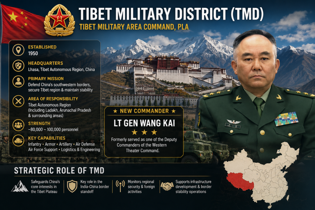
COMMAND PROFILE: LIEUTENANT GENERAL WANG KAI
Current Position: Commander, Tibet Military District (TMD) Rank: Lieutenant General (Promoted April 2021) Political Commissar: Lieutenant General Yuan Honggang Chief of Staff: Major General Thupten Trinley (Tidan Dan)
A. Career Progression & Timeline
| Year / Period | Assignment / Role | Significance & Operational Experience |
|---|---|---|
| Pre-2008 | Commander, 37th Division (13th Army) | Led a premier mountain warfare division based in Sichuan/Chongqing. |
| May 2008 | Wenchuan Earthquake Relief Commander | Led 37th Division into Beichuan and Yingxiu Town (epicenter). Navigated extreme geohazards (landslides, quake lakes). Won ‘5-12’ National Model for Earthquake Relief title. |
| 2009 | Chief of Staff, 14th Group Army | Managed staff operations and logistics for a neighboring rapid-reaction army. |
| July 2013 | Commander, 13th Group Army | Took command of one of the PLA’s most elite mountain warfare formations. Succeeded heavyweights like Xu Yong and Zhao Zongqi. |
| April 2017 | Deputy Commander, Western Theater Command Army | Transferred to Chengdu. Gained critical experience in joint operations and theater-level logistics during the 2017 PLA reforms. |
| 2019 | PRC 70th Anniversary Commemorative Medal | Recognized for long-term strategic contributions to national defense. |
| April 2021 | Commander, Tibet Military District | Appointed to lead the TMD; elevated to Lieutenant General. Oversees the entire Eastern and Central LAC sectors. |
B. The “13th Group Army” Legacy (A Stepping Stone to the CMC)
Wang Kai’s tenure as Commander of the 13th Group Army (which was reorganized into the 77th Group Army in 2017) is highly significant. The 13th GA was the PLA’s premier high-altitude/mountain warfare testing ground. The commanders who held this billet immediately prior to Wang Kai all ascended to the absolute highest echelons of the Chinese military:
| Predecessor | Tenure (13th Group Army) | Subsequent Peak Career Achievement |
|---|---|---|
| Gen. Zhang Youxia | 2000 – 2005 | Vice Chairman of the Central Military Commission (CMC) (Current top military official under Xi Jinping). |
| Gen. Zhao Zongqi | 2007 – 2009 | Commander of the Western Theater Command (Oversaw the 2017 Doklam standoff). |
| Gen. Xu Yong | 2008 – 2013 | Commander of the Tibet Military District (Oversaw massive early infrastructure buildup). |
| Lt. Gen. Wang Kai | 2013 – 2017 | Current Commander of the TMD (Overseeing the post-Galwan militarization). |
Analyst Note: The trajectory of these commanders proves that the PLA views high-altitude mountain warfare command experience not as a peripheral assignment, but as a mandatory crucible for future top-tier national military leadership.
C. Strategic Implications of Wang Kai’s Appointment
1. Mastery of High-Altitude Crisis Logistics (The 2008 Wenchuan Factor) Wang Kai’s defining early career moment was the 2008 Wenchuan Earthquake (May 12, 8.0 Ms). The earthquake triggered 200,000 landslides and 800 quake lakes, completely destroying road networks in mountainous terrain.
- Relevance to TMD: Commanding troops in the Himalayas requires the exact same skill set: operating in environments where roads are destroyed by avalanches, bridges are washed out, and air mobility is severely restricted by thin air and weather. Wang Kai’s firsthand experience in managing degraded supply lines, rapid engineer deployments, and helicopter lift operations in destroyed mountain terrain makes him uniquely suited for Himalayan border logistics.
2. Deep Integration with the Western Theater Command (WTC) By serving as the Deputy Commander of the WTC Army in Chengdu (2017–2021) immediately before taking the TMD helm, Wang Kai was instrumental in integrating the newly reformed Group Armies into the Theater Command structure. Because the TMD holds a unique “sub-theater” status and must coordinate closely with the PLAAF and PLARF (Rocket Force) based in Chengdu, Wang Kai’s deep institutional ties to the WTC headquarters ensure seamless joint-operations coordination during a border crisis.
3. Continuity of Aggressive Border Posture Wang Kai assumed command of the TMD in April 2021, roughly 10 months after the deadly Galwan Valley clash and during the peak of the Eastern Ladakh military buildup. His appointment signaled Beijing’s intent to maintain a hardened, uncompromising, and highly professional military posture along the Line of Actual Control, relying on a commander who understands both the tactical realities of mountain infantry and the strategic imperatives of the Central Military Commission.
| Category | Details (Tibet Military District / Chinese Forces) | Assessment / Strategic Impact |
|---|---|---|
| 1. Relative Force Levels | • ~50,000 troops in the TMD itself, with an estimated 200,000-230,000 Chinese ground forces in the broader Tibet region. • TMD commands approximately 50,000 personnel organized into specialized brigades. • Forward-deployed approximately 50,000 troops along the border since 2020. • In the Nyingchi region: 2 mountain infantry brigades; 1 mechanized infantry brigade at Lhasa. | Maintains a massive troop presence of roughly 200,000 along the border, organized into specialized high-altitude brigades. |
| 2. Infrastructure | • 5 major airports in Tibet: Lhasa Gonggar, Nyingchi Mainling, Shigatse Peace, Ngari Gunsa, and Chamdo Bangda. • All major airports are dual-use (military/civilian) facilities. • Qinghai-Tibet Railway (QTR) provides critical logistics backbone for sustained operations. • Invested approximately 10 times more in highway network compared to the opposing side. • Building 30 airports in Tibet and Xinjiang for military transport. • 16 new PLAAF air bases under construction along the border. • Network of 15 new airports/heliports built between 2017-2021, with 22 upgraded facilities. | Significant infrastructure advantage with better road networks, major airbases with longer runways, and railway connectivity. |
| 3. Mobility | • 5-6 dedicated logistics brigades emplaced in Tibet Military District for rapid sustainment. • Qinghai-Tibet Railway enables rapid troop and equipment movement from interior China. • Network of high-altitude heliports across Tibetan Plateau for vertical lift operations. • Z-20 utility helicopters specifically deployed to Tibet since 2020 for high-altitude operations. • Truck-mounted howitzers and mobile systems provide enhanced tactical mobility. | Strategic mobility advantage (railway, highways) for rapid reinforcements from the interior. |
| 4. Firepower | • Upgraded artillery with truck-mounted howitzers replacing towed systems for better range and mobility. • 104 missiles could strike targets across the border (including DF-31A ICBMs). • Heavy artillery, air defense systems, and rocket forces in Ngari and Shigatse regions. • Superior long-range firepower and precision strike capabilities. • Mechanized and armored brigades with modern equipment. | Quantitative and technological advantage in long-range strike capabilities and missiles. |
| 5. Logistics | • 5-6 logistics brigades specifically dedicated to Tibet Military District operations. • Joint Logistic Support Force established in 2015 reforms for integrated sustainment. • Qinghai-Tibet Railway provides economical and efficient supply for prolonged operations. • Better logistics infrastructure overall with superior road and rail networks. • Dual-use airports enable civilian-military logistics integration. | Superior strategic logistics (railway, highways, automation) for sustained operations. |
| 6. Terrain Advantages | • High ground advantage: Tibetan Plateau averages 4,500m elevation. • Defensive depth: Bases positioned 150-300 km from the border provide strategic depth. • Plateau positioning: Can observe opposing movements from elevated positions. • Challenges: Thin air affects troop performance and equipment efficiency. | Altitude and high-ground advantage, though thin air poses operational and physiological challenges. |
| 7. Air Support | • 5 major airbases: Lhasa Gonggar, Nyingchi Mainling, Shigatse Peace (all dual-use). • 16 new PLAAF air bases under construction along the border. • Network of heliports: 15 new facilities built 2017-2021. • Z-20 helicopters: High-altitude optimized utility helicopters deployed since 2020. • Can support large number of aircraft with adequate SAM coverage. • Runway advantages: Longer runways capable of supporting heavy transports and fighters. | Quantitative advantage in airbase infrastructure and numbers, with longer runways supporting heavy payloads. |
| 8. Operational Reach | • Strategic reach: Qinghai-Tibet Railway enables rapid reinforcement from interior China. • Limited by altitude: High-altitude operations constrain sustained combat effectiveness. • 150-300 km depth: Forces positioned further from the border require longer deployment times. • Missile strike capability: 104 missiles can reach opposing targets. • Air mobility: Network of airbases and heliports extends operational reach. | Superior strategic reach for reinforcements from the interior, extending operational reach via air mobility. |
Overall Strategic Assessment
Chinese Advantages:
- Superior infrastructure (roads, railways, airbases)
- Better strategic logistics and sustainment
- Quantitative advantage in firepower and missiles
- High-altitude positioning
- Rapid reinforcement capability via railway
Key Finding: Roughly 200,000 troops are deployed along the border, creating a stable balance of forces. China holds infrastructure and firepower advantages, utilizing the terrain and technological advancements to project power in the Himalayan theater.
| Strategic Assessment Area | Key Details & Analysis |
|---|---|
| 1. Operational Role | Primary Border Defense & Deterrence: The TMD’s foremost role is to deter and defeat military incursions along the Line of Actual Control (LAC) in the Eastern and Central sectors. • Internal Security & Stability: Maintaining strict internal control over the Tibet Autonomous Region (TAR) to prevent separatist movements and ensure political security. • Strategic Shield: Acting as a massive geographical and military shield for the Chinese interior, securing the Qinghai-Tibet plateau and its critical strategic assets (nuclear silos, radar networks). • Power Projection: Providing a staging ground for potential PLA power projection into South Asia, supporting the Western Theater Command (WTC). |
| 2. Capability | High-Altitude Mechanized Warfare: Unique capability to operate mechanized and armored units (like Type 15 light tanks and CSK181 vehicles) at altitudes exceeding 4,500 meters. • Integrated Firepower: Seamless integration of ground artillery (PCL-181 howitzers), Army Aviation (Z-20 helicopters), and the PLA Rocket Force (PLARF). • C4ISR Dominance: Extensive network of high-altitude radar, electronic warfare (EW) nodes, and UAV surveillance providing real-time situational awareness over the Himalayas. |
| 3. Strengths | Unmatched Infrastructure: Backed by the world’s most robust high-altitude logistics network, including the Qinghai-Tibet Railway, dense all-weather highways, and dual-use airports. • Strategic Depth & Terrain: Bases located 150–300 km behind the LAC provide immense defensive depth and a high-ground advantage. • Technological Modernization: Rapid induction of next-generation equipment specifically designed for cold, high-altitude environments. • Direct CMC Reporting: Bypasses standard bureaucratic channels for rapid strategic decision-making by reporting directly to the Central Military Commission. |
| 4. Weaknesses | Tyranny of Terrain and Altitude: Thin air degrades physical performance, reduces helicopter lift, and decreases payload/range. Requires long acclimatization. • Lack of Recent Combat Experience: No major war since 1979; lacks the continuous real-world high-altitude combat experience of opposing forces. • Logistical Chokepoints: Final approaches rely on limited mountain passes and bridges, which are highly vulnerable to precision strikes. • Troop Sustainment: Harsh environment makes long-term deployment grueling; heavy reliance on troop rotation impacts unit cohesion and terrain familiarity. |
| 5. Reinforcement Potential | High Strategic Surge Capacity: Draws upon the vast reserves of the Western Theater Command (and potentially the Central Theater Command). • Scale: Capable of rapidly flowing tens of thousands of additional troops and heavy equipment from the interior (Lanzhou, Xi’an, Chengdu). Rail and road expansions have exponentially increased this surge capacity. |
| 6. Mobilization Time | Peacetime to High Alert: Hours. Maintains high readiness with rapid-response border defense units already positioned near the LAC. • Strategic Reinforcement: 24 to 72 hours. Heavy combined-arms brigades moved from interior garrisons to forward staging areas via railway and strategic airlift. • Tactical Deployment: Slower. Moving from staging areas to the actual LAC takes time due to steep mountain roads, though pre-positioned stocks help mitigate supply delays. |
| 7. Logistics Sustainability | Peacetime/Short-Term: Highly sustainable. Pre-positioned ammunition, fuel, and winter supplies can sustain high-intensity operations for several weeks. • Prolonged Wartime: Vulnerable. Sustaining a prolonged war is a major challenge due to fragile mountain ecology, limited pass capacity, and the massive volume of fuel/ammunition required for mechanized operations. |
| 8. Likely Wartime Mission | Phase 1 (Deterrence & Defense): Absorb initial thrusts, hold the LAC, and use missile/air forces to degrade opposing airbases, logistics hubs, and communication nodes. • Phase 2 (Limited Offensives): Launch localized offensives to seize tactically vital terrain and chokepoints to create bargaining chips, avoiding deep penetration that would overextend logistics. • Phase 3 (Consolidation & Attrition): Dig into defensive positions on captured high ground and use long-range fires to attrit counter-attacks, forcing a negotiated settlement. |
| 9. Importance in Regional Strategy | The “Anvil” of the Western Theater: Pins down over 200,000 opposing troops in the mountains, preventing their reallocation to the maritime domain (Indian Ocean) or the Pakistan border. • Securing the Nuclear Deterrent: Secures interior bases for mobile ICBMs and strategic bombers, ensuring a secure second-strike capability. • Geopolitical Leverage: Controls the “third border” overlooking the heartland of South Asia, projecting influence into Nepal, Bhutan, and the Himalayas to keep the region within its strategic orbit. |
BORDER INFRASTRUCTURE
| Infrastructure Category | Key Details & Strategic Assessment |
|---|---|
| 1. Border Villages & Settlements | Scale: 628 border villages constructed (2018-2022), 175 additional under development (2024). 900 total built by 2020. • Strategic Locations: Zhuangnan (7 km from LAC, walled complexes), Majiduncun (<10 km from border, helipads), Yarao (26 km from border, 65+ buildings), Kuiqiongmen (hillside outpost). • Dual-Use Nature: Civilian settlement and military support, “Military-Civil Fusion”, establishing permanent population presence for territorial claims and rapid military mobilization. |
| 2. Roads & Railways | Highways: G219 (3,486 km in Tibet, military specs), G349 (Lhasa to Nyingchi). Massive investment in all-weather roads built directly to the LAC. • Railways: Qinghai-Tibet Railway (QTR), Lhasa-Nyingchi Railway, Lhasa-Shigatse line (extending to Yadong). Total rail network exceeds 5,000 km, providing a critical logistics backbone. |
| 3. Bridges & Mega-Dams | Bridges: Yarlung Tsangpo River Bridges (e.g., Zangmu Railway Bridge). Built for heavy military traffic and year-round connectivity across major river systems. • Mega-Dams: Yarlung Tsangpo Lower-Reach Hydropower Project (world’s largest, under construction 2025-2026, 50 km from Arunachal border). Dual civilian-military strategic infrastructure. |
| 4. Airstrips & Airbases | Primary Airports: Lhasa Gonggar, Nyingchi Mainling, Shigatse Peace (36 HAS, J-20 deployed), Ngari Gunsa, Chamdo Bangda. • New Construction: 16 new PLAAF air bases under construction (2024-2026), all >14,000 ft elevation. • Key Facilities: Lhunze (36 HAS), Tingri (14,100 ft), Burang. Features include Hardened Aircraft Shelters (HAS), underground fuel depots, and extended runways (3,000+ meters). |
| 5. Helipads & Heliports | Scale: 100+ helipads identified. 15 new (2017-2021), 22 upgraded. 90% situated at 3,300-5,300m elevation. • Strategic Sites: Lahza (4,000m, 845m strip), Gar County (4,300m, under construction), Lungze (near Tawang), Nagadong (near Bhutan/Sikkim), Near Pangong Tso, Bhutan Border, Nagqu. • Capabilities: Heli-strips expandable to 700-1000m for UAVs. Inventory includes Z-20, Z-8G/L, Z-21, Mi-17. |
| 6. Border Posts & Security | Police Posts: 600+ high-tech “Convenience Police Posts” with advanced surveillance. • Military Posts: Co-located with Xiaokang villages, PLA/PAP shared responsibility, fortified structures with perimeter walls. • Legal Framework: Land Borders Law (2022) codifies defense responsibilities and mandates “mass defense forces” construction. |
| 7. Surveillance & Comms | Radar: Ganbala Radar Station (5,374m, world’s highest manned, 5G upgraded). 3 additional unmanned radars. • Surveillance: High-tech cameras, night thermal, long-range sensors, and advanced EW infrastructure. • Communications: 5G deployment at radar/villages, SATCOM at heliports/airbases, and fiber-optic networks along major highways (G219, G318, G349). |
| 8. Strategic Assessment | Advantages: Comprehensive network, dual-use design, high-altitude capability, rapid construction, strategic depth (150-300 km behind LAC), and redundancy. • Key Developments (2020-2026): 628 villages, 16 airbases, 100+ helipads, 5,000+ km rail, $20B+ air investment, J-20 deployment. • Implications: Enables year-round presence, rapid mobilization, sustained logistics, integrated air-ground ops, and long-term territorial consolidation. |
Defensive Infrastructure
| Defensive Infrastructure Category | Key Details & Features |
|---|---|
| 1. Bunkers & Underground Facilities | • Underground Aircraft Hangars: Utilizes underground tunnels inside mountains for housing aircraft instead of relying solely on surface blast pens. • Bomb-Proof Shelters: Constructed at various airports to secure fighter jets from airstrikes. • Strategic Tunnel Complexes: Underground facilities (e.g., near Ngari airbase) used to preposition ammunition and fuel. • Missile Bunkers: Ballistic missiles stockpiled in underground tunnels built directly into mountainsides. • Retractable Roofs: Hidden missile bunkers equipped with retractable roofs to maintain a low profile until launch. • Border Bunker Complexes: Numerous underground tunnels and bunker complexes at border facilities along strategic stretches of the LAC. |
| 2. Defensive Trenches & Fortifications | • Pangong Tso Network: Significant fortified trenches constructed between Fingers 4 and 5, accompanied by around 500 structures and a new boatshed. • Long-Term Foothold: Trench networks indicate investment in a significant, long-term military presence near remote areas. • Winter Tunnels: New underground tunnels specifically designed for winter shelter at the high-altitude border hotspot of Doklam. |
| 3. Permanent Defensive Positions | • Air Defense Sites: Five permanent air defense positions established to secure key corridors. • Year-Round Deployments: Infrastructure upgrades compel permanent deployments on its side of the LAC to balance operations year-round, even in harsh winters. • Border Defense Companies: Permanently stationed on or near the LAC, armed with light infantry weapons and supported by armored personnel carriers. |
| 4. Observation Towers | • High-Altitude Surveillance: High observation towers constructed along the LAC to look directly into opposing defenses and deny traditional grazing grounds. • Concrete CCTV Towers: Equipped with CCTV cameras to continuously monitor troop movements. • Frontline Towers: Continued building of military infrastructure along the border, including new frontline observation towers. • Flashpoints: Construction of observation tents and towers has been a direct trigger for violent border clashes (e.g., 2020 Galwan Valley). |
| 5. Blast Shelters & Hardened Aircraft Shelters (HAS) | • Lhunze Airbase Expansion: Completed construction of 36 hardened aircraft shelters, along with new administrative blocks and an expanded apron. • Massive Shelter Network: Doubled hardened shelters from about 370 in the 2010s to over 800 across its inventory. • Precision Strike Protection: Specifically designed to protect aircraft against precision-guided munitions, airstrikes, or missile barrages. |
| 6. Camouflage Facilities & Techniques | • Low-Visibility Camouflage: Special techniques with practical use in high-altitude border defense missions. • Type 03 “Tibet-Tarn”: Specialized plateau camouflage pattern featuring sage green and olive-grey colors adapted for harsh highland conditions. • Type 19 “Starry Sky”: Newer camouflage schemes introduced to blend into rocky, high-altitude terrain. • Deception & Concealment: Advanced satellites capable of mapping underground tunnels and hidden cables inform counter-surveillance and concealment strategies. |
| 7. Winter-Specific Defensive Infrastructure | • Modular Winter Quarters: New modular container-based accommodations for soldiers along the LAC to survive extreme sub-zero temperatures. • Plateau Portable Barracks: Equipping Tibetan military bases with portable barracks specifically designed for high-altitude plateau areas. • Specialized Shelters: Modular bunkers and winter quarters built for specific uses along the border, ensuring troops remain combat-effective during the harsh Himalayan winter. |
Intelligence and Surveillance Infrastructure
| Intelligence & Surveillance Category | Key Details & Features |
|---|---|
| 1. Radar Stations | • Ganbala Radar Station: World’s highest manned radar station (5,374m) in Yadong County, recently upgraded with 5G connectivity for high-speed data transmission to command centers. • Passive Coherent Location (PCL) Radars: Passive sensing systems that detect aircraft by analyzing reflections off civilian broadcast signals (FM radio, TV towers), making them extremely difficult to detect and jam. • Air Defense & Early Warning Network: An estimated 17 major radar stations and associated missile launch bases provide continuous early warning and tracking coverage across the Tibetan Plateau. |
| 2. SIGINT & ELINT Facilities | • HF/DF Networks: Expanded High-Frequency Direction Finding passive sensing networks along the border to intercept and geolocate military radio communications. • Ground Collection Sites: Multiple ground stations in Tibet and Xinjiang tasked with mapping radar frequencies, intercepting tactical communications, and monitoring missile test telemetry. • Special Mission Aircraft Infrastructure: Upgraded bases (e.g., Shigatse Peace, Nyingchi Mainling) support Y-9 and Y-8 variant SIGINT/ELINT aircraft for deep-penetration electronic surveillance without crossing the LAC. |
| 3. Satellite Communication Stations | • PLA Ground Segment: Dedicated radio satellite communication stations and affiliated tracking stations identified across Tibet. • Guowang Megaconstellation: Deployment of satellite internet megaconstellation and Satellite-Enabled IoT networks to transmit real-time field data from remote, uninhabited areas of the plateau. • Forward SATCOM Terminals: Major heliports, border villages, and forward operating bases equipped with advanced SATCOM domes for encrypted links with theater and central command. |
| 4. Optical Observation Posts | • Concrete CCTV Towers: Permanent concrete towers equipped with high-definition CCTV, thermal imaging, and night-vision sensors to continuously monitor troop movements and traditional grazing grounds. • Dominating Heights: Forward-deployed posts strategically stationed on dominating heights (e.g., overlooking Torsa defile and Doklam plateau) providing direct visual and laser-targeting coverage. • Automated Sensor Mesh: Optical posts integrated into a broader sensor mesh that automatically alerts nearby artillery and drone units to patrols crossing perceived claim lines. |
| 5. UAV Bases | • Ngari High-Altitude UAV Test Base: Inaugurated in late 2025 in western Tibet (>4,300m elevation); China’s first drone test base specifically designed to test and operate UAVs in thin-air, high-altitude environments. • Forward Operating Locations (FOLs): Airbases in Shigatse, Nyingchi, and Lhasa feature expanded aprons and specialized hangars to support HALE drones (CH-5, WZ-7, GJ-11). • Tactical Drone Proliferation: Exponential increase in tactical UAV deployment since the 2020 standoff, with combined arms brigades now operating their own organic quadcopter and loitering munition fleets. |
| 6. Electronic Warfare (EW) Sites | • Brigade-Level EW Assets: Expanded electronic warfare capabilities at the Combined Arms Brigade level, featuring mobile EW battalions designed to jam tactical radios and GPS/navigation signals during skirmishes. • Integrated Network Electronic Warfare (INEW): Physical co-location of EW jammers with cyber-attack nodes to simultaneously blind sensors and disrupt command networks. • Regular EW Drills: Routine military exercises incorporating EW systems, spectrum management, and command operations to ensure readiness in highly contested electromagnetic environments. |
| 7. Cyber Support Infrastructure | • Cyberspace Force Integration: The newly reorganized PLA Cyberspace Force manages offensive and defensive cyber capabilities, with regional nodes supporting theater operations. • Fiber-Optic Backbone: Extensive, hardened fiber-optic cable networks laid alongside strategic highways (G219, G318, G349) provide the high-bandwidth, low-latency infrastructure required for real-time cyber operations and AI-driven ISR processing. • AI and Cloud Espionage: Increasing reliance on AI-driven operations to process massive amounts of data collected by border sensors, while specialized cyber units target military networks and critical infrastructure via cloud-based espionage tactics. |
Logistics Infrastructure
| Logistics Infrastructure Category | Key Details & Features |
|---|---|
| 1. Highways | • National Highway 219 (G219): Strategic arterial road running along the western and southern borders, crucial for lateral troop and logistics movement along the LAC. • National Highways 318 (G318) & 109 (G109): Major axial routes connecting the Tibetan Plateau to interior China (Sichuan and Qinghai provinces). • Specifications: Upgraded to all-weather, military-grade standards to support heavy transport vehicles year-round, ensuring uninterrupted supply lines. |
| 2. Military Roads | • Network: Dense network of paved, all-weather military roads connecting major highways directly to the Line of Actual Control (LAC). • Connectivity: Links newly built “Xiaokang” border villages, forward operating bases, and artillery positions. • Capacity: Engineered with high load-bearing capacities to allow the movement of heavy armor, mechanized infantry, and logistics convoys in extreme terrain. |
| 3. Railways | • Qinghai-Tibet Railway (QTR): Primary strategic logistics backbone connecting Golmud to Lhasa, enabling mass transport of troops and heavy equipment. • Lhasa-Nyingchi Railway: Critical 435-km line boosting logistical support in the eastern sector. • Sichuan-Tibet Railway: Under construction to link Chengdu to Nyingchi, drastically reducing transit time from the Sichuan basin. • Lhasa-Shigatse Railway: Connects central/western sectors, with plans to extend to the border town of Yadong. |
| 4. Bridges | • Scale: Massive construction component due to deep river gorges; the Lhasa-Nyingchi railway alone features 120 bridges (75% of the line consists of bridges and tunnels). • Capacity: Engineered to military specifications, capable of bearing the immense weight of main battle tanks, heavy artillery, and fully loaded logistics convoys. |
| 5. Tunnels | • Protection: Vital for shielding logistics routes from extreme weather, avalanches, and potential aerial interdiction. • Key Tunnels: Lhasa-Nyingchi railway passes through 47 tunnels (including the massive Milin tunnel); QTR features the Fenghuoshan Tunnel (world’s highest rail tunnel at 4,905m); Sichuan-Tibet railway includes 10+ tunnels longer than 10 km. |
| 6. Fuel Depots | • Storage: Underground depots constructed at major airbases (e.g., Shigatse, Lhunze) to protect aviation fuel from precision strikes. • Distribution: Forward dumps managed by dedicated logistics brigades; mobile fuel trucks and pipeline networks ensure rapid distribution from railheads to forward tactical units. |
| 7. Ammunition Depots | • Facilities: First underground ammunition storage facility located near TMD headquarters. • Pre-positioning: Massive dumps established near the LAC to allow units to rapidly expend fuel and ammunition during a conflict. • Security: Underground tunnel complexes built into mountainsides securely store ballistic missiles, artillery shells, and small arms ammunition. |
| 8. Supply Warehouses | • Shared Backbone: “Public warehouses” allow units to draw on pre-stocked tents, generators, and supplies rather than transporting them everywhere. • Civil-Military Fusion: Massive smart logistics centers built by civilian companies leveraged for military operations. • Specialized Storage: Dedicated warehouses maintained for winter supplies, including cold-weather gear, high-calorie rations, and modular heated barracks. |
| 9. Logistics Hubs | • Xigatse (Shigatse): Major military logistics hub identified to support operations in the central and western sectors. • Xining Joint Logistics Support Center: Provides overarching rail and road-based sustainment for TMD forces. • Central Convergence: Lhasa and Nyingchi serve as primary hubs where rail, air, and road networks converge to distribute supplies to forward areas. |
| 10. Medical Facilities | • High-Altitude Care: Specially equipped to treat high-altitude illness, requiring storage and supply of oxygen for newly arrived troops. • Border Infrastructure: Dedicated oxygen stations built along border roads to allow soldiers to recover stamina during patrols. • Integration: Military medical system integrated with heavily invested civilian hospitals receiving support from top-tier medical teams from interior China. |
| 11. Communications Infrastructure | • C4I2SR Network: Expanded infrastructure featuring dozens of VSAT satellite stations (up to 70 in the TAR) to ensure secure, redundant communication links. • 5G Deployment: High-altitude radar stations and border villages equipped with 5G networks to enable high-speed data transmission for command and control. |
| 12. Fiber Optic Networks | • Coverage: Extensive optical fiber communication (OFC) infrastructure laid to connect all 55 counties of the TAR. • Routing: Cables primarily routed alongside strategic highways and railway lines to protect them from environmental damage. • Capability: Provides the high-bandwidth, low-latency backbone required for real-time ISR data processing, secure communications, and network-centric warfare. |
| 13. Power Infrastructure | • Grid Upgrades: Central Tibet Power Interconnection Project features 16 substations at or above 110kV (including six at 500kV) and 2,738 km of transmission lines. • Reliability: Ensures reliable power for military installations, radar stations, and heating systems. • Off-Grid Solutions: Remote border posts and surveillance towers increasingly utilize micro-grids, solar panels, and wind turbines to ensure energy independence. |
Missile Bases and Capabilities
| Missile Category / System | Key Details & Capabilities |
|---|---|
| 1. SRBM & MRBM (DF-15 / DF-16) | • Missile Type: DF-15B/C (SRBM) and DF-16B/C/E (MRBM, featuring a penetrator warhead for hardened targets). • Launchers: 30-50 road-mobile TELs (6×6 for DF-15, 8×8 for DF-16) deployed in forward bases in Tibet and Qinghai. • Range & Coverage: DF-15 (600-900 km), DF-16 (800-1,500+ km). Covers the entire LAC, forward airbases in the plains, and critical chokepoints like the Siliguri Corridor. • Mobility & Storage: Highly mobile on upgraded highways; stored in extensive underground “Great Wall” tunnel complexes with retractable camouflage roofs for direct launch. • Reload: 15 to 30 minutes using Transporter-Launcher-Reload (TLR) vehicles. |
| 2. IRBM & HGV (DF-21 / DF-26 / DF-17) | • Missile Type: DF-21 (MRBM/IRBM), DF-26 (dual-capable IRBM), and DF-17 (Hypersonic Glide Vehicle specifically designed to defeat advanced air defenses like the S-400). • Launchers: 20-40 heavy 8×8 or 10×10 TELs across the broader Western Theater Command. • Range & Coverage: DF-21 (1,800-3,000 km), DF-26 (3,000-4,000+ km, reaches the Indian Ocean Region), DF-17 (1,800-2,500 km). Covers all of India, including deep interior targets and southern naval bases. • Mobility & Storage: Restricted to major high-load-bearing highways; stored in deep, climate-controlled underground facilities in interior provinces. • Reload: 45 to 90 minutes using heavy TLR vehicles. |
| 3. Land Attack Cruise Missiles (CJ-10 / DF-10) | • Missile Type: CJ-10 / DF-10 Long-range Land Attack Cruise Missile. • Launchers: 20-30 heavy 8×8 TELs carrying a cluster of four launch tubes (80-120 ready-to-fire missiles). • Range & Coverage: 1,500 to 2,500 km. Flies at low altitudes with complex waypoint routing to bypass radar networks and strike deep-rear command centers, communications nodes, and airbases. • Mobility & Storage: Highly mobile; can launch from concealed valleys or forests. Stored in climate-controlled underground bunkers near firing units. • Reload: 1 to 2 hours to fully reload a 4-tube TEL using specialized crane vehicles. |
| 4. Surface-to-Air Missiles (HQ-9B / HQ-22 / HQ-16) | • Missile Type: HQ-9B (Long-range), HQ-22 (Medium/Long-range), and HQ-16 (Medium-range). • Launchers: 40-60 TELs for HQ-9/HQ-22 (8×8 carrying 4 missiles) plus numerous short-range systems. • Range & Coverage: HQ-9B (200-250+ km), HQ-22 (~170 km), HQ-16 (40-70 km). Denies airspace over the Tibetan Plateau and deep into opposing territory. • Mobility & Storage: Road-mobile, deploying to pre-surveyed hardened positions. Interceptors stored in hardened, climate-controlled underground bunkers adjacent to sites. • Reload: 20 to 30 minutes per missile for the HQ-9 using manual or semi-automated cranes. |
| 5. Strategic Assessment & Posture | • Shift to Conventional: Heavy shift toward conventional precision strikes for potential border conflicts, supported by massive conventional ammunition depots and specialized warhead storage. • Survivability: Reliance on the “Underground Great Wall” ensures missiles are hidden deep underground, making them highly survivable against preemptive airstrikes. • A2/AD Bubble: Dense SAM deployment integrated with early warning radars creates a formidable Anti-Access/Area Denial network designed to neutralize opposing air superiority. • First-Strike Advantage: SRBMs and Cruise Missiles are postured to conduct a massive first strike against forward airbases, radar stations, and logistics nodes in the first 24-48 hours of a conflict to paralyze opposing forces. |
PLAAF & TMD Airbases in the Western Theater Command (WTC)
| Airbase (Code) | Role / Sector | Elevation | Runway (Length / Orientation) | Aircraft & Capacity | Infrastructure (HAS, Shelters, Hangars, Fuel) | Air Defense & Radar | Logistics & UAVs |
|---|---|---|---|---|---|---|---|
| Shigatse Peace Airport (RKZ / ZURK) | Primary PLAAF strike & stealth fighter hub (Central sector) | 3,750 m (12,300 ft) | 5,000 m (16,400 ft) 13/31 (130°/310°) | Capacity: 100+ (incl. surge) Aircraft: J-20, J-11BH, J-16, Y-20, Il-76, Y-9 SIGINT | HAS: 36+ massive concrete (expanded for 5th-gen) Shelters: Numerous earth-covered/surface revetments Hangars: Multiple large-scale for heavy transports/stealth Fuel: Extensive underground farms & surface hydrants | Systems: HQ-9B, HQ-22, PGZ-09 SPAAG Radar: Integrated early warning; terminal guidance for SAMs | Logistics: Major WTC hub (Lhasa-Shigatse rail, G318); massive underground munitions depots UAVs: Dedicated aprons, sheds, launch rails for WZ-7, CH-5 |
| Lhasa Gonggar Airport (ZALS / ZULS) | Central command, control & strategic airlift hub (TMD) | 3,570 m (11,700 ft) | 4,000 m (13,100 ft) 09L/27R (090°/270°) | Capacity: 150+ Aircraft: J-10C, J-11B, Y-20, Y-9, Z-20, Mi-17 | HAS: ~30+ concrete Shelters: Dozens of earth-bermed & concrete surface Hangars: Large Y-20 maintenance facilities Fuel: Massive underground depots (pipelined to apron) | Systems: HQ-9, HQ-16, MANPADS Radar: Primary approach control; integrated with Ganbala high-altitude network | Logistics: Central TMD node (Qinghai-Tibet rail/highway); primary joint logistics command center UAVs: Shared medium-altitude drone operating areas |
| Nyingchi Mainling Airport (LZY / ZUNY) | Critical forward airbase (Eastern Sector / Arunachal Pradesh) | 2,949 m (9,675 ft) | 3,000 m (9,800 ft) 14/32 (140°/320°) | Capacity: 80–100 Aircraft: J-10C, J-11B, J-16, Y-8 SIGINT, Z-20 | HAS: ~20+ Shelters: Earth-bermed perimeter shelters Hangars: Standard PLA maintenance Fuel: Underground & surface tank farms | Systems: HQ-9B, HQ-17 (short-range mobile) Radar: Specialized valley approach radars; linked to tactical data link | Logistics: Closest major base to Eastern LAC (Lhasa-Nyingchi highway/rail) UAVs: Dedicated hangars/launch facilities for tactical & HALE UAVs |
| Ngari Gunsa Airport (NGQ / ZUAL) | Primary hub for Western Sector (Aksai Chin / Ladakh) | 4,411 m (14,470 ft) | 4,500 m (14,760 ft) 15/33 (150°/330°) | Capacity: 50–70 Aircraft: J-11, Y-20, MA60, WZ-7, CH-5 | HAS: ~12–15 Shelters: Limited surface (extreme terrain) Hangars: Large extreme-cold maintenance Fuel: Specialized high-altitude temp-controlled underground | Systems: HQ-9B, HQ-22 Radar: High-altitude coverage over Western Sector & deep into Indian airspace | Logistics: Western Sector hub (G219 highway); relies on rail to Lhasa then trucking UAVs: China’s 1st high-altitude UAV testing base (late 2025); dedicated drone runways/hangars |
| Chamdo Bangda Airport (BPX / ZUBD) | Strategic airlift & eastern reserve hub | 4,334 m (14,219 ft) | 5,500 m (18,040 ft) 14/32 | Capacity: 100+ Aircraft: J-10, J-11, Y-20, Il-76 | HAS: ~20+ Shelters: Earth-covered revetments Hangars: Large-scale maintenance Fuel: Massive underground depots | Systems: HQ-9, HQ-12 Radar: Covers Eastern Tibet & Sichuan basin approaches | Logistics: Major airlift hub connecting eastern Tibet to interior China UAVs: Standard tactical drone operations |
| Lhunze (Longzi) Airbase | Newly expanded, highly aggressive forward strike base | ~3,900 m (12,800 ft) | ~4,000 m (13,100 ft) ~10/28 | Capacity: 60–80 Aircraft: J-10C, J-11, multi-role fighters, UAVs | HAS: Exactly 36 newly constructed (2023–2024) Shelters: New construction surface Hangars: New admin & maintenance blocks Fuel: Newly constructed underground | Systems: HQ-9B, HQ-16 Radar: Immediate tactical coverage of Tawang, eastern Sikkim, Arunachal border | Logistics: Very close to LAC; rapid-reaction hub for Central/Eastern sectors UAVs: Expanded aprons specifically for drone integration |
| Tingri Airbase | Central/high-altitude forward base near Nepal border | ~4,300 m (14,100 ft) | ~5,000 m (16,400 ft) ~14/32 | Capacity: 50+ Aircraft: J-11, J-10C, transports, UAVs | HAS: ~20+ (recently expanded) Shelters: Earth berms Hangars: Standard PLA maintenance Fuel: Underground storage | Systems: HQ-9B Radar: Covers Nepal/India border & central Himalayas approaches | Logistics: Road-connected to G318; backup/surge base for Shigatse UAVs: High-altitude drone operations |
| Burang (Purang) Airbase | Central-western sector forward base | ~4,255 m (13,960 ft) | ~4,500 m (14,700 ft) ~12/30 | Capacity: 40–50 Aircraft: Transports, Z-20, Mi-17, tactical UAVs | HAS: ~12–15 Shelters: Earth-covered Hangars: Maintenance facilities Fuel: Surface & underground tanks | Systems: HQ-16, HQ-17 (mountain point defense) Radar: Covers Lipulekh pass / Uttarakhand sector of LAC | Logistics: Supports central-western sector (G219 highway network) UAVs: Tactical drone operations |
Strategic Summary of the Airbase Network
| Strategic Aspect | Details |
|---|---|
| Military-Civil Fusion | Almost all of these airbases are “dual-use” facilities. This allows the PLA to mask military build-ups under the guise of civilian aviation expansion, while legally leveraging civilian infrastructure for military logistics under Chinese law. |
| Runway Superiority | The runways in Tibet (especially Bangda at 5,500m and Shigatse at 5,000m) are significantly longer than most Indian Air Force (IAF) forward airbases. This allows Chinese aircraft to take off with maximum fuel and weapons payloads, partially offsetting the lift-degrading effects of high altitude. |
| Survivability | The massive investment in Hardened Aircraft Shelters (HAS) and underground tunnel complexes ensures that a preemptive strike by the IAF would fail to destroy the PLAAF on the ground. |
| UAV Integration | The establishment of dedicated high-altitude UAV testing and operating bases (like Ngari) highlights the PLA’s reliance on drones to conduct persistent ISR and strike missions in an environment where human pilots face severe physiological limits. |
PLA Weapons and Equipment Deployed in the Tibet Military District (TMD) and Western Theater Command (WTC)
| Category | System / Equipment | Type / Role | Key Features & Deployment Context |
|---|---|---|---|
| Armored Vehicles & Ground Combat | Type 96A/B | Main Battle Tank (MBT) | Primary workhorse in lower-altitude Tibet/WTC. 125mm smoothbore gun, improved armor. |
| Type 99A | Main Battle Tank (MBT) | Premier 3rd-gen MBT. Deployed in WTC for strategic reserves/broader valleys (too heavy for highest passes). | |
| Type 15 (ZTQ-15) | Light Tank | Critical for high-altitude/mountainous terrain. ~35 tons, hydropneumatic suspension, 105mm rifled gun. | |
| ZBD-04A | Infantry Fighting Vehicle (IFV) | Heavy tracked. 100mm low-pressure gun, 30mm autocannon. Upgraded powerpacks for 4,500+ meters. | |
| ZBL-08 | Infantry Fighting Vehicle (IFV) | 8×8 wheeled. 30mm autocannon, HJ-73C ATGMs. Highly mobile on paved highways. | |
| CSK-181 | Armored Personnel Carrier (APC) | 4×4 high-mobility. Rapid troop transport, patrol, weapons carrier (12.7mm HMG/35mm AGL). | |
| ZSL-92B | Armored Personnel Carrier (APC) | 6×6 wheeled. Logistical convoys and troop movement. | |
| ZFB-05 | Light Assault Vehicle | Light 4×4. Reconnaissance and Quick Reaction Forces (QRF). | |
| ZTL-11 | Assault Gun / Tank Destroyer | 8×8 wheeled. 105mm rifled gun. Highly mobile on mountain roads. | |
| Artillery & Fire Support | PCL-181 | 155mm Truck-Mounted Howitzer | Highly mobile, shoot-and-scoot. Proven in Pangong Tso/Doklam sectors. |
| PCL-161 | 122mm Truck-Mounted Howitzer | Lighter/compact for rugged, narrow mountain roads. | |
| PLZ-05 | 155mm Tracked SPH | Self-propelled howitzer. | |
| PLL-05 | 120mm SP Mortar-Gun | Self-propelled mortar-gun. | |
| PHL-191 | Modular MLRS | Fires 300mm/370mm rockets (potential TBMs). Range up to 500km. | |
| PHL-16 | 300mm Tracked MLRS | Tracked multiple launch rocket system. | |
| PHL-03 | 122mm Wheeled MLRS | Based on Russian BM-30 Smerch. | |
| PCP-001 | 120mm SP Multiple Mortar | Self-propelled multiple mortar system. | |
| PP-89 | 100mm AGL / Mortar | Automatic grenade launcher / mortar. | |
| Portable 82mm & 120mm | Man-Portable Mortars | Indirect fire in defilade for mountain infantry. | |
| Missile Systems | HQ-9B | Long-Range SAM | 200+ km range. Backbone of A2/AD bubble over Tibet. |
| HQ-22 | Long-Range SAM | Cheaper alternative to HQ-9, deployed in larger numbers. | |
| HQ-16B / HQ-16FE | Medium-Range SAM | 70-160 km range. | |
| HQ-17AE | Short-Range SAM | 15 km range, tracked chassis, protects advancing armor. | |
| FM-3000 / LD-3000 | Very Short-Range / C-RAM | Counter Rocket, Artillery, Mortar systems. | |
| FN-6 / QW-18 | MANPADS | Man-portable air-defense for frontline infantry. | |
| DF-15B/C | Short-Range Ballistic Missile | ~600-900 km range. | |
| DF-16B/C/E | Medium-Range Ballistic Missile | ~1,000-1,500 km. DF-16E features penetrator warhead for bunkers. | |
| DF-21D / DF-26 | Intermediate-Range Ballistic Missile | Deployed in broader WTC; strikes deep into India/Indian Ocean. | |
| DF-17 | Hypersonic Glide Vehicle | Medium-range HGV designed to defeat advanced air defenses (e.g., S-400). | |
| CJ-10 / DF-10 | Land-Attack Cruise Missile | ~1,500-2,500 km range. | |
| CJ-100 / DF-100 | Supersonic/Hypersonic Cruise Missile | Advanced cruise missile systems. | |
| Unmanned Aerial Systems (UAS) | WZ-7 (Soaring Dragon) | HALE UAV | Crucial for persistent ISR over the Himalayas. |
| CH-5 (Rainbow 5) | MALE UCAV | Carries precision-guided munitions. | |
| GJ-11 (Sharp Sword) | Stealth UCAV | Flying wing design; tested at Ngari high-altitude base. | |
| BZK-005 / BZK-008 | Reconnaissance/Strike UAV | Long-range drones. | |
| ASN-209 | Tactical Recon Drone | Hand-launched or small-runway. | |
| DJI Mavic / Matrice | COTS Quadcopters | Tactical overwatch and dropping small munitions by infantry squads. | |
| ZC-2000 / Micro-UAVs | Swarm / Loitering Munitions | Swarm-capable for special operations. | |
| Electronic Warfare (EW) & Radar | KG300G | ECM System | Ground-based and airborne electronic countermeasures. |
| JH-90 / JYG-1 | Tactical Jamming | Communications jamming deployed at brigade level. | |
| Y-9G / Y-8G | EW / SIGINT Aircraft | Dedicated aircraft operating from Tibet airbases. | |
| YLC-8B | UHF Mobile Early Warning Radar | Detects stealth aircraft; effective at high altitudes. | |
| YLC-2E / JY-27A | VHF Stealth-Hunting Radar | Anti-stealth radar systems. | |
| SLC-7 | Multi-Function S-Band Radar | Target tracking and engagement. | |
| SLC-2E | Counter-Battery Radar | Mobile phased-array; tracks incoming artillery for retaliation. | |
| Type 305 | Low-Altitude Surveillance Radar | Detects cruise missiles/helicopters masking in valleys. | |
| HT-233 | Fire-Control Radar | Specifically for the HQ-9 SAM system. | |
| Aviation | Z-20 | Medium Utility Helicopter | 10-ton. 4-blade rotor, engines tuned for thin air; outperforms Mi-17 at 5,000+ m. |
| Z-10 / Z-19 | Attack / Recon Helicopter | Dedicated attack and reconnaissance. | |
| Z-8G / Z-8L | Heavy-Lift Helicopter | Wide-body transport helicopters. | |
| Mi-171 | Utility Helicopter | Russian-made workhorse, being supplemented by Z-20. | |
| J-20 | 5th-Gen Stealth Fighter | Deployed to Shigatse/Lhasa to secure air superiority. | |
| J-16 | Heavy Multirole Strike Fighter | Primary deep-strike asset in the WTC. | |
| J-11B / J-11BG | Air Superiority Fighter | Primary air dominance fighters. | |
| J-10C | Light Multirole Fighter | Highly maneuverable. | |
| Y-20 | Heavy Strategic Airlifter | Transports Type 15 tanks and heavy logistics. | |
| Y-9 | Medium Tactical / Special Mission | Transport, EW, and SIGINT base. | |
| Il-76MD | Heavy Transport | Russian-made heavy airlifter. | |
| Logistics, Support & Infrastructure | BeiDou (Military Terminals) | Navigation / Comms | Precise positioning and short-burst messaging (GPS independent). |
| 5G Military Networks | Communications | Deployed at high-altitude radar stations/border villages for high-bandwidth data. | |
| Skylink-1 | Airborne Data Link | High-speed coordination for fighters and drones. | |
| TA5510 / TAS5380 | Heavy Tactical Trucks | 8×8 and 10×10 for moving armor and artillery. | |
| Dongfeng EQ2102 / EQ2050 | Light/Medium Tactical Trucks | Standard logistical transport. | |
| High-Mobility ATVs | All-Terrain Vehicles | ATVs and snowmobiles for last-mile patrol in extreme snow. | |
| Modular Container Barracks | Infrastructure | Prefabricated, insulated, heated living quarters. | |
| High-Altitude O2 Generators | Life Support | Stationary and portable concentrators for 4,500+ meters. | |
| Heavy Cargo Drones | Logistics | Large multi-rotor drones ferrying ammo/food to isolated outposts. | |
| Mobile Field Kitchens & MREs | Rations / Logistics | Self-heating MREs generate heat via chemical reactions (no firewood needed). | |
| GQL-111 / GQL-410 | Armored Bridge Layers | Mechanized bridges on tank chassis to span ditches/ravines. | |
| EZV Pontoon Bridges | Bridging Equipment | For crossing swift, glacial Himalayan rivers. | |
| Specialized Mountain Warfare | Powered Exoskeletons | Infantry Gear | Passive/active exoskeletons to carry 30-50 kg up steep 5,000m passes. |
| Type 19 / Type 21 Plateau Camo | Uniforms | Sage green, olive-grey, “starry sky” patterns. Includes heated insoles/thermal layers. | |
| Individual O2 Equipment | Life Support | Portable cylinders and nasal cannulas to prevent Acute Mountain Sickness (AMS). | |
| Mule and Yak Corps | Animal Logistics | Thousands of yaks/mules for “last-mile” logistics in steep/fragile terrain. | |
| Mountain Guns (Legacy) | Towed Artillery | Mule-packable 75mm recoilless guns and lightweight 120mm mortars. |
Force Composition of Major Military Installations in the Tibet Military District (TMD) and Western Theater Command (WTC)
| Garrison / Location | Strategic Role & Sector Focus | Troop Strength & Personnel Status | Ground Combat Forces (Infantry, Armor, Artillery, AD, SOF) | Support, EW & Logistics | Aviation Assets (PLAGF & PLAAF) |
|---|---|---|---|---|---|
| 1. Lhasa Garrison (TMD Headquarters) | Strategic command center, heavy armor reserve, and central logistics hub. | Est: 15k–20k (PLAGF) + ~3k (PLAAF). Permanent: High (TMD HQ, 54th Heavy CAB, 85th SOF). Rotational: Medium (3–6 mo acclimatization). Reserve: Primary strategic reserve for TMD. | SOF: 85th SOF Bde (“Snow Leopards”). Mech Inf: 54th Heavy CAB (ZBD-04A IFVs). Armor: Type 96A/B MBTs; Type 15 staged. Arty: TMD Arty Bde (PHL-191 MLRS, PCL-181 155mm). AD: TMD AD Bde (HQ-9B, HQ-22). | Engrs: 15th Engineer Bde. EW: TMD Info Support/EW Bns. Logistics: Xining Joint Logistics Support Center (TMD Node); massive permanent brigades, fuel/ammo dumps. | PLAGF: TMD Army Aviation Bde (Z-20, Z-10, Z-8G, Mi-17). PLAAF: Gonggar Airport (Y-20, Il-76). |
| 2. Nyingchi / Linzhi Garrison | Primary forward offensive hub for the Eastern Sector (facing Arunachal Pradesh). | Est: 15k–18k (PLAGF) + ~2k (PLAAF). Permanent: Very High (52nd & 53rd Mountain CABs at 2,900m). Rotational: Medium (to 4,500m+ posts). Reserve: Backed by WTC rapid reaction via Lhasa-Nyingchi railway. | SOF: 85th SOF detachments. Mtn/Mech Inf: 52nd & 53rd Mountain CABs (ZBL-08, CSK-181). Armor: Organic Type 15 Light Tanks. Arty: PCL-161 (122mm), PCL-181 (155mm). AD: Organic HQ-17AE, PGZ-09. | Engrs: Organic combat engineer bns (mountain road repair). EW: Organic EW companies (tactical jammers, drone CM). Logistics: Forward logistics bns (pre-positioned winter supplies/ammo). | PLAGF: Forward helipads (Z-20 for medevac/lift). PLAAF: Mainling Airport (J-10C, J-16). |
| 3. Shigatse / Xigaze Garrison | Central sector strike and air superiority hub (Nepal/India border). | Est: 8k–10k (PLAGF) + ~4k (PLAAF). Permanent: High (motorized inf, airbase security). Rotational: High (PLAAF fighters 1–2 mo tours). Reserve: Staging area for WTC reserves. | Mtn/Mech Inf: Motorized inf (G318 optimized); CSK-181, ZSL-92B. Armor: Type 15, ZTL-11 (rotational). Arty: Forward PCL-181 batteries. AD: Heavy concentration (HQ-9B, HQ-22). | Engrs: Highway maintenance & airbase repair detachments. EW: Ground-based EW nodes (anti-radiation protection). Logistics: Major railhead hub (Lhasa-Shigatse terminus); massive underground storage. | PLAAF: Shigatse Peace Airbase (J-20, J-16, WZ-7 HALE UAVs). Extensive HAS & underground facilities. |
| 4. Ngari / Ali Garrison | Extreme high-altitude border defense hub, Western Sector (Ladakh/Aksai Chin). | Est: 5k–8k (PLAGF) + ~1.5k (PLAAF/PLARF). Permanent: Very High (fully acclimatized to 4,300m+). Rotational: Low (relies on locals to avoid AMS). Reserve: Limited; relies on air-resupply/rapid reinforcement. | SOF: Small recon teams (Galwan/Pangong Tso). Mtn Inf: Border Defense Regiments (exoskeletons, O2). Mech Inf: CSK-181, ATVs, snowmobiles. Armor: Type 15, ZTL-11 (forward staging). Arty: Towed 122mm, PCL-161. AD: HQ-16, HQ-17AE. | Engrs: Specialized high-altitude road/bridge units. EW: Tactical EW teams at border posts. Logistics: Extreme-environment logistics (heavy-lift drones, Z-8L, high-altitude trucks); massive winter supply dumps. | PLAAF: Ngari Gunsa Airport (world’s highest). Hosts transports, HALE UAVs, high-altitude drone testing base. |
| 5. Shannan / Lhunze Garrison | Aggressive forward posture, Central/Eastern Border (Sikkim, Bhutan/Doklam). | Est: 5k–7k (PLAGF) + ~2k (PLAAF). Permanent: High (border defense, airbase security). Rotational: Medium (artillery/armor from Lhasa). Reserve: Backed by 54th Heavy CAB (hours away). | SOF: Elements monitoring Doklam/Torsa. Mtn/Mech Inf: Border defense regiments; CSK-181, ZBL-08. Armor: Type 15 (permanently staged in concealed positions). Arty: Heavy PCL-181 concentration. AD: HQ-9B, HQ-16. | Engrs: Continuous road-widening/tunnel construction. EW: Permanent ground-based SIGINT/ELINT sites. Logistics: Forward supply depots connected to Lhasa railhead. | PLAAF: Lhunze Airbase (36 new HAS). Hosts J-10C, J-11 fighters for immediate air cover. |
| 6. Chamdo / Qamdo Garrison | Strategic rear hub, Eastern Reserve & Logistics (connects Tibet to Sichuan/interior). | Est: ~5k (PLAGF) + ~3k (PLAAF). Permanent: High (logistics, engineering, airbase security). Rotational: Very High (reception area from Sichuan). Reserve: Hosts WTC-level reserve stockpiles. | Mtn Inf: Training/acclimatization centers. Armor: Staging areas for heavy armor. AD: HQ-12, HQ-9 protecting Bangda airbase. | Engrs: Major highway construction/maintenance commands (G318, G349). EW: Strategic SIGINT nodes (eastern approaches). Logistics: Massive joint logistics hub (offloading/distributing rail/air cargo). | PLAAF: Chamdo Bangda Airport (5,500m runway). Hosts heavy transport regiments (Y-20, Il-76); critical strategic airlift node. |
Administrative and Operational Hierarchy of the Tibet Military District (TMD)
| Echelon Level | Organization / Unit Type | Command Headquarters | Role & Responsibilities | Specific Units / Designations |
|---|---|---|---|---|
| 1. Supreme Command | Central Military Commission (CMC) | Beijing (CMC Joint Operations Command Center) | Supreme military command authority. Due to TMD’s sub-theater status and political sensitivity, the TMD Commander and Political Commissar have direct reporting lines to the CMC for strategic/administrative matters, bypassing standard WTC bureaucracy. | N/A |
| 2. Theater Command | Western Theater Command (WTC) | Chengdu, Sichuan Province | Responsible for all joint military operations in China’s west, including the India border. Provides the joint operational framework (integrating Air Force, Rocket Force, and strategic logistics) under which the TMD operates tactically. | N/A |
| 3. Sub-Theater / Provincial Command | Tibet Military District (TMD) / Tibet Military Area Command | Lhasa, Tibet Autonomous Region (TAR) | Primary ground force formation for the Tibet sector. Commands all PLAGF units in the TAR. Equivalent in size and firepower to a Group Army but holds a higher administrative rank (Sub-Theater), allowing it to command combat brigades directly. | N/A |
| 4. Tactical Combat Echelon | Combined Arms Brigades (CAB) & Specialized Brigades | Various garrisons across the TAR | Primary maneuver and fire-power elements. In the post-2016 structure, traditional “Group Army,” “Corps,” and “Division” echelons are bypassed; the TMD commands these brigades directly. | 52nd & 53rd Mountain CABs (Nyingchi); 54th CAB (Lhasa/Gonggar – heavy armor reserve); 85th Special Operations Brigade (Lhasa); TMD Artillery, Air Defense, and EW/Information Support Brigades. |
| 5. Regional / Garrison Echelon (Sub-District) | Military Sub-Districts (Jun Fenqu) | Prefectural capitals across Tibet (e.g., Shigatse, Chamdo, Ngari) | Responsible for regional defense, recruitment, and civil-military relations. Equivalent to a Division in administrative rank, but they command static Border Defense Regiments directly rather than large maneuver divisions. | Shigatse, Nyingchi, Ngari Military Sub-Districts, etc. |
| 6. Regional / Garrison Echelon (Regiment) | Border Defense Regiments (BDR) / Battalions (BDB) | Key border towns or forward logistical hubs | Primary infantry formations holding the Line of Actual Control (LAC). Light infantry heavily equipped for mountain warfare, cold weather, and high-altitude survival. | Numbered sequentially or by geographic sector (e.g., 1st, 11th BDR). Specific Military Unit Numbers (MUNs) are highly classified and frequently rotated. |
| 7. Tactical Edge Echelon (Company) | Border Defense Company | Forward operating bases, large “Xiaokang” border villages, or fortified camps a few km behind the LAC | Commands 3 to 5 platoons. Responsible for a specific sector of the border, conducting daily patrols, maintaining forward outposts, and managing civilian militia integration (“mass defense”). | Designated by parent regiment (e.g., “3rd Company, 11th Border Defense Regiment”). |
| 8. Tactical Edge Echelon (Post) | Border Defense Post (Bianfang Shaoqia) | Fortified bunkers, observation towers, or trench networks directly on the LAC or dominating heights | The absolute tactical edge. Conducts visual/drone surveillance, engages in face-to-face standoffs, and holds physical ground. Manned by a single platoon (30-40) or squad (10-15) in extreme locations. Commanded by a Lt or Sr Sgt. | Numerical (e.g., “Post 4300” based on elevation) or geographic (e.g., “Kaurik Post”, “Finger 4 Post”). |
| 9. Unit Designations & Naming | Dual-Naming System (Public & MUN) | N/A | Public Designation (Fanhao): Used in state media/ceremonies. Military Unit Number (MUN / Daihao): 5-digit code for operational security, mail, and internal comms. Cover Designations: Tactical border units often integrated into civilian entities (e.g., XPCC/TPCC, border management bureaus) for plausible deniability. | Public: e.g., “52nd Mountain CAB”, “85th SOF Bde”. MUN: e.g., “PLA Unit 65xxx”. Note: Strategic MUNs are tightly controlled; Tactical MUNs are strictly classified and rotated after major incidents. |
Major TMD Airbases & Installations
| Installation Name | Approx. Coordinates | Elevation | Nearby Towns | Distance from LAC / Opposing Posts | Key Features / Notes |
|---|---|---|---|---|---|
| Lhasa Gonggar Airport / TMD HQ | 29.2978°N, 90.9119°E | 3,570 m | Gonggar County (~5 km), Lhasa (~60 km NW) | ~150-200 km (varies by sector) | Serves as TMD Headquarters and primary strategic airlift hub. |
| Shigatse Peace Airport | 29.3519°N, 88.6178°E | 3,750 m | Shigatse (~40 km east) | ~130-150 km to central sector | Central sector strike and air superiority hub. |
| Nyingchi Mainling Airport | 29.3061°N, 94.3350°E | 2,949 m | Nyingchi (~50 km west), Mainling County | ~40-60 km to Arunachal border; ~50-80 km from Indian posts | Lowest elevation of major Tibet airbases, allowing higher payloads. |
| Ngari Gunsa Airport | 32.1000°N, 80.0500°E | 4,411 m | Shiquanhe (~120 km SE) | ~50-80 km to Ladakh/Aksai Chin; ~60-100 km from Indian posts | Highest airport in the world; primary hub for the Western Sector. |
| Lhunze (Longzi) Airbase | 28.4200°N, 92.4800°E | ~3,900 m | Lhunze County | ~20-40 km to Arunachal/Sikkim; ~30-50 km from Tawang sector | Highly aggressive forward strike base with recent expansion (2022-2024). |
| Tingri Airbase | 28.6700°N, 87.1300°E | ~4,300 m | Tingri (New Tingri) | ~40-60 km to Nepal/India tri-junction | Central/high-altitude forward base acting as a surge base for Shigatse. |
| Chamdo Bangda Airport | 30.5536°N, 97.1083°E | 4,334 m | Bangda, Chamdo (~130 km west) | ~150-200 km (eastern sector rear area) | Features a 5,500m runway (one of the world’s longest) for heavy high-altitude takeoffs. |
| Burang (Purang) Airbase | 30.2800°N, 81.2200°E | ~4,255 m | Burang County, Taklakot | ~30-50 km to Uttarakhand/HP border; ~40-70 km from Lipulekh Pass | Central-western sector forward base. |
Border Villages & Forward Positions (Xiaokang)
| Village Name | Approx. Coordinates | Elevation | Distance from LAC | Key Features |
|---|---|---|---|---|
| Majiduncun | ~28.5°N, 92.3°E | N/A | ~10 km | Helipads and integrated military facilities. |
| Zhuangnan | ~28.4°N, 92.2°E | N/A | ~7 km NW | Military/paramilitary complexes equipped with radome towers. |
| Yarao | ~28.6°N, 92.4°E | 3,900 m | ~26 km | 65+ identical buildings and two helipads. |
Geospatial & Analytical Parameters
| Category | Details |
|---|---|
| Deliberate Obfuscation | Exact coordinates are often obscured in publications and analyses for operational security reasons. |
| Rapid Construction | New facilities are continuously built (especially post-2020), making static location databases quickly outdated. |
| Dual-Use Facilities | Many “civilian” airports, villages, and infrastructure have military applications, complicating precise categorization. |
| Classification Levels | Public: General location (town/county level). Restricted: Precise coordinates (100m accuracy). Classified: Exact targeting data (<10m accuracy). |
| Verification | Coordinates must be cross-referenced with multiple sources before use in formal analysis. |
| Distance Variables | Distances are approximate straight-line (as-the-crow-flies) measurements and vary based on: • Specific sector of the LAC (which is disputed). • Terrain and actual road distances (often 2-3x longer). • Specific opposing post used as a reference point. • Ongoing infrastructure development. |
| Calculation Tools | Precise distance and elevation calculations typically require GIS software (ArcGIS, QGIS), satellite imagery measurement tools, topographic maps, and verified GPS coordinates. |
Maps, Visual Materials, and Geospatial Data Guide: Tibet Military District & Border Infrastructure
1. Mapping, Imagery & GIS Resources
| Category | Resource / Platform | Key Details & Capabilities |
|---|---|---|
| Interactive Maps & Publications | Takshashila Geospatial Bulletin | Transport infrastructure mapping, 3D city maps (ESRI), military expansion analysis. |
| ASPI (MappingDoklam) | Interactive 3D maps of India-China-Bhutan tri-junction, geolocated military/infrastructure. | |
| CSIS China Power Project | Database of military infrastructure, satellite imagery, LAC tracking. | |
| Al Jazeera Interactives | Detailed dispute maps with elevation and terrain data. | |
| Commercial Satellite Providers | Maxar Technologies (WorldView) | 30cm-50cm resolution, historical archives, widely used by defense analysts. |
| Planet Labs (SkySat / Dove) | Daily monitoring, 3-5m (Dove) / 50cm (SkySat) resolution. | |
| Airbus (Pleiades) | Very high-resolution optical imagery for detailed facility analysis. | |
| Public Satellite & GIS Data | Google Earth / Maps | Historical imagery tracking; major airbases, roads, and border villages visible. |
| Copernicus Sentinel-1 (ESA) | Free, open-access radar imagery; all-weather, day/night capability. | |
| CAS Earth Data | Shapefiles for county/prefecture administrative boundaries. | |
| GIS Software | ESRI ArcGIS (standard for 3D/defense analysis) and QGIS (open-source alternative). |
2. Terrain, Infrastructure & Logistics Networks
| Category | Network / Feature | Key Details & Statistics |
|---|---|---|
| Terrain & Elevation | Tibetan Plateau | Average elevation >4,500m; covers ~2.5 million sq km. |
| Sino-Indian Border | “High-altitude mountainous area” >3,000m; peaks up to 6,500m (21,000 ft). | |
| Aksai Chin | Average elevation ~6,000m in Karakoram ranges. | |
| Strategic Impact | Imposes “severe constraints” on operations; complex roads create logistical challenges and an “escalation trap”. | |
| Military Road Networks | National Highways | G219 (western/southern border), G318 (Sichuan-Tibet), G109 (Qinghai-Tibet), G349. |
| Network Statistics | 41,000 km road network in Tibet; renovated to military standards; all-weather roads to LAC. Investment is 10x that of India. | |
| Indian Border Roads | ICBR project, Arunachal Frontier Highway (1,700 km), BRO completed 4,764 km (2014-20). | |
| Railway & Logistics | Railway Network | Qinghai-Tibet (backbone), Lhasa-Nyingchi (435 km), Lhasa-Shigatse, Sichuan-Tibet (under construction). Total >5,000 km. |
| Logistics Hubs | Xigatse, Lhasa, Xining Joint Logistics Support Center. Highway-rail-air integrated network. | |
| Capabilities | Rapid reinforcement from interior, 5-6 dedicated logistics brigades, underground fuel/ammo depots. |
3. Military Installations & Deployments
| Installation Type | Documented Sites & Coordinates | Key Capabilities & Visual Evidence |
|---|---|---|
| Airbases | Lhasa Gonggar (29.29°N, 90.91°E) Shigatse Peace (29.35°N, 88.61°E) Nyingchi Mainling (29.30°N, 94.33°E) Ngari Gunsa (32.10°N, 80.05°E) Chamdo Bangda (30.55°N, 97.10°E) Lhunze, Tingri, Burang | 16 new PLAAF bases above 14,000 ft. Expansions at Hotan, Ngari, Lhasa. Visuals show active SAMs, J-20s at Shigatse, UAV testing at Ngari. |
| Missile Sites (PLARF) | Underground storage near TMD HQ, mountain tunnels. | DF-26 expansions (2024). Coverage: DF-15/16 (600-1,500 km), DF-21/26 (1,800-4,000+ km). |
| Air Defense (SAMs) | HQ-9B / HQ-22 deployments at major airbases. | 5 permanent AD positions identified. Active deployments visible via satellite. Range: 200-250+ km (airspace denial). |
| Radar Network | Ganbala (5,374m, 5G upgraded), ~17 major stations. | YLC-8B (UHF stealth), YLC-2E/JY-27A (VHF), SLC-2E (counter-battery), Type 305 (low-altitude). Early warning for entire plateau. |
| Documented Flashpoints | Pangong Tso, Galwan Valley | Permanent structures, underground bunkers, pre/post-2020 clash buildup. |
4. Research Access, Datasets & Methodology Notes
| Category | Details |
|---|---|
| Access Levels | Free Public: Google Earth, Copernicus Sentinel, CSIS, ASPI. Academic/Commercial: Maxar, Planet Labs, Jane’s, IISS, ResearchGate. Classified: Real-time ISR, exact targeting coordinates. |
| Academic Datasets | Population datasets (ArcGIS), transport GIS, border incursion analysis, truck-mounted drone tracking. |
| Coordinate Precision | Public sources provide 100m-1km accuracy; exact targeting data (<10m) is strictly classified. |
| Timeliness & Verification | Infrastructure evolves rapidly; imagery must be date-stamped and cross-referenced. Dual-use civilian facilities often have military applications. |
| Legal / Ethical Use | Materials are intended for research and academic purposes only. |
Pingback: U.S. Army Comprehensive Unit Directory (2026) | SARO