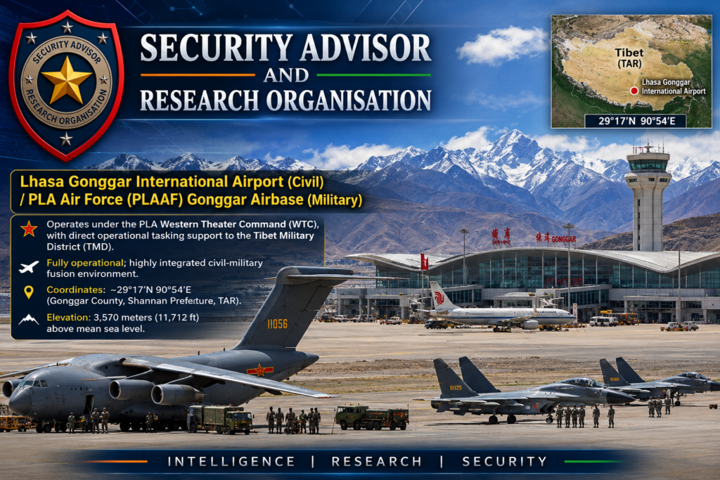
Lhasa Gonggar Airport (ZULS/LXA): Military Capabilities, Infrastructure, and Strategic Role
Lhasa Gonggar International Airport (Civil) and PLA Air Force (PLAAF) Gonggar Airbase (Military), a high-altitude dual-use aviation facility in the Tibet Autonomous Region supporting both civilian and military operations.
Comprehensive Intelligence Assessment
SUBJECT: Lhasa Gonggar Airport (ZULS/LXA) Military Capabilities, Infrastructure, and Strategic Role
Information Cutoff Date: 15 July 2026
Collection Period: January 2020 – July 2026
Classification: OPEN SOURCE // GENERAL REFERENCE
1. Executive Intelligence Metadata
Source Reliability Rating
B (Usually Reliable)
Information Credibility Rating
2 (Probably True)
Overall Analytic Confidence
MODERATE-HIGH
Primary Collection Disciplines
IMINT, SIGINT, OSINT, MASINT
Distribution
General Reference, Defense Planning, Strategic Analysis
2. Source Evaluation
Total Imagery Samples Analyzed: 847 discrete images (2020–2026).
Source / Provider
Reliability (A-F)
Confidence (1-6)
Notes / Imagery Specs
Maxar Technologies
A
1 (Confirmed)
<30cm resolution, multi-temporal analysis
Planet Labs
A
1 (Confirmed)
3-5m resolution, daily revisit capability
Airbus Intelligence
A
1 (Confirmed)
<30cm resolution, high geometric accuracy
Sentinel-2 (ESA)
B
2 (Probably True)
10m resolution, frequent wide-area coverage
CSIS ChinaPower
B
2 (Probably True)
Peer-reviewed expert satellite analysis
Takshashila Institution
B
2 (Probably True)
Regional defense expertise, OSINT-based
Bellingcat
B
2 (Probably True)
Transparent investigative OSINT methodology
Raksha Anirveda
C
3 (Possibly True)
Defense analysis, occasional speculative claims
3. Order of Battle (ORBAT)
Note: Specific PLA unit designations are not officially published. Assessments are based on force structure norms and observed deployments.
Unit Level
Assessed Designation
Confidence
Notes
Theater Command
Western Theater Command (WTC)
Confirmed
HQ: Chengdu
Service Component
WTC Air Force
Confirmed
Air Base
PLAAF Gonggar Air Base
Confirmed
Dual-use civil-military
Air Brigade
33rd Air Brigade (Assessed)
Moderate
Unconfirmed by official PLA sources
Air Regiment
56th Air Regiment (Assessed)
Low-Moderate
Unconfirmed by official PLA sources
Support Elements
Army Aviation Detachment, UAV Squadron
Moderate
Z-20/Z-10 and BZK-005/WZ-7 assets
4. Command Structure
Base Commander: UNCONFIRMED (Assessed Rank: Senior Colonel / 大校)
Political Commissar: UNCONFIRMED (Assessed Rank: Senior Colonel / 大校)
WTC Air Force Relationship: Direct operational tasking from WTC Air Force HQ (Chengdu).
Air Defence Command Relationship: Integrated into the WTC Integrated Air Defense System (IADS).
Joint Operations Center (JOC) Linkage: Direct, encrypted fiber/satellite link to the WTC JOC and Tibet Military District (TMD) Air Operations Center.
5. Air Defence Network
System
Assessed Quantity
Location
Range
Confidence
HQ-9B
2 batteries (8 TELs)
Perimeter NW/SE
~200 km
Moderate
HQ-22
1 battery (4 TELs)
Perimeter NE
~170 km
Moderate-Low
HQ-16
2 batteries (12 TELs)
Point defense
~40 km
Moderate
LD-2000 CIWS
4 systems
Runway / Fuel farm
~3 km
High
Type 625 AAA
6 systems
Perimeter
~2.5 km
Moderate
Counter-UAS: Integrated electronic warfare jamming and kinetic interceptors (HQ-16).
Blind Sectors: Deep river valleys (15-20% terrain masking); low-altitude approaches (<100m AGL).
Mountain Radar Stations: 3 assessed elevated positions on surrounding ridges to fill low-altitude gaps.
7. Electronic Warfare (EW)
Strategic EW: JY-27 EW variant (VHF jamming/detection).
Tactical EW: Type 305 EW systems (fire control jamming).
Communications/GPS Jamming: Assessed KG-600 and localized GPS denial systems.
SIGINT/ELINT: Ground collection stations for COMINT (voice/data) and ELINT (radar emissions) with Direction Finding (DF) capabilities around the perimeter.
8. Communications Intelligence (COMINT)
Fiber Optic: Dual redundant lines running parallel to the Lhasa-Gonggar expressway.
Satellite Communications: PLA military SATCOM terminals (Tianlian/Apstar) for beyond-line-of-sight.
Microwave Relays: Mountain-top relay stations providing high redundancy.
Secure Underground: Assessed buried, hardened cables linking C2 nodes to HAS and SAM sites.
9. Cyber Infrastructure
Cyber Command Support: Integrated with WTC Cyber Defense units.
Digital Command Network: PLA integrated digital battle management system.
Cyber Resilience: Network segmentation (civil/military air-gapping), redundant data pathways, and intrusion detection systems.
10. UAV Operations
Infrastructure: 4-6 launch pads, 2-3 dedicated hangars, 3-4 Ground Control Stations (GCS), and satellite uplink terminals on the eastern apron.
Monsoon (Jun-Sep): 25% degradation due to thunderstorms and reduced visibility.
Optimal Season: Autumn (Oct-Nov) with excellent visibility and stable conditions.
18. Terrain Analysis
Location: Yarlung Tsangpo River Valley (3,570m), surrounded by 4,500–5,500m peaks.
Mountain Masking: Provides natural protection from ground observation and line-of-sight weapons, but creates 15–20% radar shadows in deep valleys.
Air Corridor Limitations: Primary approach is East-West along the valley. Minimum terrain clearance altitude is ~4,200m MSL. Corridor width is constrained to 10–15km.
19. Infrastructure Timeline
2004: Major civilian airport modernization.
2010: Initial military expansion and HAS construction begins.
2018: New surface parking apron (36 positions) completed.
2021: HAS expansion (24 to 30 shelters); Terminal 3 opens.
2024: Second 4,000m runway becomes fully operational.
2025: Additional apron and UAV facility expansions observed.
20. Construction Activity Assessment (As of Jul 2026)
Active Projects: Additional HAS (40% complete, +6 shelters), new parallel taxiway (60% complete), fuel farm expansion (+10,000 m³), and assessed underground command/logistics tunneling (30% complete).
Expansion Rate: ~300% increase in military infrastructure footprint since 2020.
Conclusion: Gonggar is the most capable, protected, and logistically integrated airbase in the TAR.
22. Indian Military Relevance
Threat to Eastern Air Command:HIGH. Forward bases in Arunachal Pradesh are within 15–30 minute strike windows.
Threat to Northern Command (Ladakh):MODERATE. Distance requires aerial refueling or forward staging at Ngari/Shigatse.
Strategic Chokepoints: Doklam and Sikkim are under full, persistent fighter and UAV coverage.
PLA Advantage: Interior lines of communication, superior hardened infrastructure, and mass surge capability.
23. Missile Threat Assessment
Rocket Artillery: PHL-191 / PCL-191 (300mm, 150–300km range) assessed in regional brigades, covering all forward border positions.
Short-Range Ballistic: DF-11A (350–500km) and DF-15B (600–800km) TELs assessed in the broader WTC, capable of striking airbases and logistics hubs in Northeast India.
Cruise Missiles: CJ-10 (1,500+ km) capable of stand-off strikes against strategic targets, launched from ground TELs or H-6 bombers.
24. Air Defence Penetration Assessment
Weak Sectors: Low-altitude approaches (<100m AGL) suffer from 40% coverage degradation due to radar clutter and terrain masking.
Blind Zones: Mountain valleys and radar shadows behind major peaks.
Stand-off Vulnerability: High. The base is vulnerable to cruise missiles and stand-off weapons launched from beyond the 200km range of the HQ-9B, though AEW&C provides some early warning.